Khoroshyovsky District: Difference between revisions
Appearance
Content deleted Content added
Added population, area update |
Added history |
||
| Line 65: | Line 65: | ||
|date=August 2011 |
|date=August 2011 |
||
}} |
}} |
||
'''Khoroshyovsky District ''' ({{lang-ru|Хорошёвский райо́н}}) is an administrative district ([[raion]]) of [[Northern Administrative Okrug]], and one of the 125 raions of [[Moscow]], [[Russia]].<ref name="OKATO">{{OKATO reference|45}}</ref> The area of the district is {{convert|8.54|km2|sqmi|sp=us}}. Population: 56,600 (2017 est.)<ref name="about">{{cite web|title=General Information|url=http://khoroshevskiy.mos.ru/about/missiya/|publisher=Khoroshyovsky District|language=russian|access-date=February 5, 2018}}</ref> <!-- ([[Russian Census (2002)|2002 Census]]); {{su-census1989||.}} --> |
'''Khoroshyovsky District ''' ({{lang-ru|Хорошёвский райо́н}}) is an administrative district ([[raion]]) of [[Northern Administrative Okrug]], and one of the 125 raions of [[Moscow]], [[Russia]]. |
||
<ref name="OKATO">{{OKATO reference|45}}</ref> Central to the district is [[Khodynka Field]], which, as an open space in the northwest of Moscow was long the site of agriculture, battles, celebrations and the first airfield in Russia. The area of the district is {{convert|8.54|km2|sqmi|sp=us}}. Population: 56,600 (2017 est.)<ref name="about">{{cite web|title=General Information|url=http://khoroshevskiy.mos.ru/about/missiya/|publisher=Khoroshyovsky District|language=russian|access-date=February 5, 2018}}</ref> <!-- ([[Russian Census (2002)|2002 Census]]); {{su-census1989||.}} --> |
|||
==History== |
|||
The district takes its name from the now-filled Khodynka River, a former left tributary of the Moscow River just to the south.<ref name='history'>{{cite web|title=History of the District|url=http://khoroshevskiy.mos.ru/about/polozhenie_o_departamente/|publisher=Khoroshyovsky District|language=ru|accessdate=February 22, 2108}}</ref> |
|||
==See also== |
==See also== |
||
Revision as of 04:32, 23 February 2018
Khoroshyovsky District
Хорошёвский район | |
|---|---|
 Khoroshovskoye chaussée (highway), Khoroshyovsky District | |
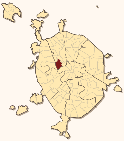
 Location of Khoroshyovsky District on the map of Moscow | |
| Coordinates: 55°47′18″N 37°31′46″E / 55.78833°N 37.52944°E | |
| Country | Russia |
| Federal subject | Moscow |
| Area | |
• Total | 8.54 km2 (3.30 sq mi) |
| Population | |
• Estimate (2017)[1] | 56,600 |
| Time zone | UTC+3 (MSK |
| OKTMO ID | 45348000 |
| Website | http://khoroshevskiy.mos.ru/ |
Khoroshyovsky District (Template:Lang-ru) is an administrative district (raion) of Northern Administrative Okrug, and one of the 125 raions of Moscow, Russia. [3] Central to the district is Khodynka Field, which, as an open space in the northwest of Moscow was long the site of agriculture, battles, celebrations and the first airfield in Russia. The area of the district is 8.54 square kilometers (3.30 sq mi). Population: 56,600 (2017 est.)[1]
History
The district takes its name from the now-filled Khodynka River, a former left tributary of the Moscow River just to the south.[4]
See also
References
Notes
- ^ a b c "General Information" (in Russian). Khoroshyovsky District. Retrieved February 5, 2018.
- ^ "Об исчислении времени". Официальный интернет-портал правовой информации (in Russian). 3 June 2011. Retrieved 19 January 2019.
- ^ Государственный комитет Российской Федерации по статистике. Комитет Российской Федерации по стандартизации, метрологии и сертификации. №ОК 019-95 1 января 1997 г. «Общероссийский классификатор объектов административно-территориального деления. Код 45», в ред. изменения №278/2015 от 1 января 2016 г.. (State Statistics Committee of the Russian Federation. Committee of the Russian Federation on Standardization, Metrology, and Certification. #OK 019-95 January 1, 1997 Russian Classification of Objects of Administrative Division (OKATO). Code 45, as amended by the Amendment #278/2015 of January 1, 2016. ).
- ^ "History of the District" (in Russian). Khoroshyovsky District. Retrieved February 22, 2108.
{{cite web}}: Check date values in:|accessdate=(help)


