Yad Natan: Difference between revisions
→History: another page |
No edit summary |
||
| Line 24: | Line 24: | ||
The moshav was founded in 1953 by [[Jew]]ish immigrants from the Hungarian youth movement [[HaNoar HaTzioni]] as part of the effort to settle the region. It was named after [[Ottó Komoly]] (also known as ''Natan'' Kohn), a leader of the [[Zionism|Zionist]] movement in Hungary, who disappeared in Hungary in 1945 after being arrested by the [[Arrow Cross]].{{Citation needed|date=May 2017}} |
The moshav was founded in 1953 by [[Jew]]ish immigrants from the Hungarian youth movement [[HaNoar HaTzioni]] as part of the effort to settle the region. It was named after [[Ottó Komoly]] (also known as ''Natan'' Kohn), a leader of the [[Zionism|Zionist]] movement in Hungary, who disappeared in Hungary in 1945 after being arrested by the [[Arrow Cross]].{{Citation needed|date=May 2017}} |
||
The moshav was built 800m south and 1 km north-east, respectively, of the sites of the [[Palestinians|Palestinian]] villages of [[Bayt 'Affa]] and [[Iraq Suwaydan]], which were depopulated in 1948. It is on the land of [[Iraq Suwaydan]].<ref>Survey of Israel, map "Hebron" 1:100,000, revision of 1956.</ref><ref>{{cite book|title=All That Remains: The Palestinian Villages Occupied and Depopulated by Israel in 1948|url=https://books.google.com/books?id=_By7AAAAIAAJ |first1=Walid|last1=Khalidi|authorlink=Walid Khalidi|year=1992|location=[[Washington D.C.]]|publisher=[[Institute for Palestine Studies]]|isbn=0-88728-224-5|pages=86, 109}}</ref> |
The moshav was built 800m south and 1 km north-east, respectively, of the sites of the [[Palestinians|Arab-Palestinian]] villages of [[Bayt 'Affa]] and [[Iraq Suwaydan]], which were depopulated in 1948. It is on the land of [[Iraq Suwaydan]].<ref>Survey of Israel, map "Hebron" 1:100,000, revision of 1956.</ref><ref>{{cite book|title=All That Remains: The Palestinian Villages Occupied and Depopulated by Israel in 1948|url=https://books.google.com/books?id=_By7AAAAIAAJ |first1=Walid|last1=Khalidi|authorlink=Walid Khalidi|year=1992|location=[[Washington D.C.]]|publisher=[[Institute for Palestine Studies]]|isbn=0-88728-224-5|pages=86, 109}}</ref> |
||
==References== |
==References== |
||
Revision as of 03:53, 8 May 2018
Yad Natan
| |
|---|---|
 | |
| Etymology: Natan Memorial | |
| Coordinates: 31°39′21″N 34°42′15″E / 31.65583°N 34.70417°E | |
| Country | Israel |
| District | Southern |
| Council | Lakhish |
| Affiliation | HaOved HaTzioni |
| Founded | 1953 |
| Founded by | HaNoar HaTzioni |
| Population (2022)[1] | 631 |
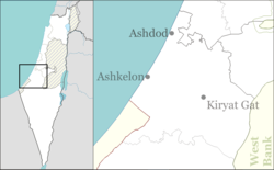
Yad Natan (Template:Lang-he-n, lit. Memorial for Natan) is a moshav in southern Israel in Hevel Lakhish, near the town of Kiryat Gat. It is part of the Lakhish Regional Council. In 2022 it had a population of 631.[1]
History
The moshav was founded in 1953 by Jewish immigrants from the Hungarian youth movement HaNoar HaTzioni as part of the effort to settle the region. It was named after Ottó Komoly (also known as Natan Kohn), a leader of the Zionist movement in Hungary, who disappeared in Hungary in 1945 after being arrested by the Arrow Cross.[citation needed]
The moshav was built 800m south and 1 km north-east, respectively, of the sites of the Arab-Palestinian villages of Bayt 'Affa and Iraq Suwaydan, which were depopulated in 1948. It is on the land of Iraq Suwaydan.[2][3]
References
- ^ a b "Regional Statistics". Israel Central Bureau of Statistics. Retrieved 21 March 2024.
- ^ Survey of Israel, map "Hebron" 1:100,000, revision of 1956.
- ^ Khalidi, Walid (1992). All That Remains: The Palestinian Villages Occupied and Depopulated by Israel in 1948. Washington D.C.: Institute for Palestine Studies. pp. 86, 109. ISBN 0-88728-224-5.

