Wuda District: Difference between revisions
Appearance
Reverted 1 edit by 123.161.169.88 (talk): The harassment here could not be more blatant. (TW) |
m ASDFGH moved page Wuda District to Ud District |
(No difference)
| |
Revision as of 02:20, 25 July 2018
Wuda
乌达区 • ᠤᠳᠠᠲᠣᠭᠣᠷᠢᠭ | |
|---|---|
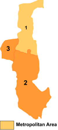
 Wuda is the division labeled '3' on this map of Wuhai City | |
| Coordinates: 39°30′21″N 106°43′03″E / 39.50583°N 106.71750°E | |
| Country | People's Republic of China |
| Prefecture-level city | Wuhai |
| Time zone | UTC+8 (China Standard) |
Wuda District (Mongolian: ᠤᠳᠠ ᠲᠣᠭᠣᠷᠢᠭ Уда тоори Uda toɣoriɣ; simplified Chinese: 乌达区; traditional Chinese: 烏達區; pinyin: Wūdá Qū) is a district of the city of Wuhai, Inner Mongolia, People's Republic of China, located on the west (left) bank of the Yellow River.
References
