Une Formation: Difference between revisions
Tisquesusa (talk | contribs) No edit summary |
Tisquesusa (talk | contribs) |
||
| Line 107: | Line 107: | ||
[[Category:Cenomanian Stage]] |
[[Category:Cenomanian Stage]] |
||
[[Category:Sandstone formations]] |
[[Category:Sandstone formations]] |
||
[[Category:Deltaic deposits]] |
|||
[[Category:Shallow marine deposits]] |
|||
[[Category:Reservoir rock formations]] |
|||
[[Category:Altiplano Cundiboyacense|Formations]] |
[[Category:Altiplano Cundiboyacense|Formations]] |
||
[[Category:Geography of Cundinamarca Department]] |
[[Category:Geography of Cundinamarca Department]] |
||
Revision as of 20:06, 26 August 2018
| Une Formation | |
|---|---|
| Stratigraphic range: Albian-Cenomanian ~ | |
| Type | Geological formation |
| Unit of | Villeta Group |
| Underlies | Chipaque Formation |
| Overlies | Fómeque Fm., Tibasosa Fm. |
| Thickness | up to 1,100 m (3,600 ft) |
| Lithology | |
| Primary | Sandstone |
| Location | |
| Coordinates | 4°27′07″N 74°03′20″W / 4.45194°N 74.05556°W |
| Region | Altiplano Cundiboyacense Eastern Ranges, Andes |
| Country | |
| Type section | |
| Named for | Une |
| Named by | Hubach |
| Location | Une |
| Year defined | 1957 |
| Coordinates | 4°27′07″N 74°03′20″W / 4.45194°N 74.05556°W |
| Region | Cundinamarca, Boyacá |
| Country | |
 Paleogeography of Northern South America 105 Ma, by Ron Blakey | |
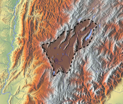
The Une Formation (Template:Lang-es, Kiu) is a geological formation of the Altiplano Cundiboyacense, Eastern Ranges of the Colombian Andes. The predominantly sandstone formation dates to the Middle Cretaceous period; Albian to Cenomanian epochs and has a maximum thickness of 1,100 metres (3,600 ft).
Etymology
The formation was defined in 1957 by Hubach after Une, Cundinamarca.[1]
Description
Lithologies
The Une Formation has a maximum thickness of 1,100 metres (3,600 ft) and is characterised by a sequence of sandstones.[2] Fossils of Heminautilus etheringtoni have been found in the Une Formation.[3]
Stratigraphy and depositional environment
The Une Formation, part of the Villeta Group, overlies the Fómeque Formation and is overlain by the Chipaque Formation. The age has been estimated to be Albian-Cenomanian. Stratigraphically, the formation is time equivalent with the Simijaca, Aguardiente, Caballos and Pacho Formations. The formation has been deposited in a near shore deltaic environment.[4]
Outcrops
The Une Formation is apart from its type locality, found on the Sumapaz Páramo.[2]
Regional correlations
See also
References
Bibliography
Maps
- Template:Cite LSA
- Template:Cite LSA
- Template:Cite LSA
- Template:Cite LSA
- Template:Cite LSA
- Template:Cite LSA
- Template:Cite LSA
- Template:Cite LSA
- Template:Cite LSA
- Template:Cite LSA
- Template:Cite LSA
- Template:Cite LSA
- Template:Cite LSA
External links
- Geologic formations of Colombia
- Cretaceous Colombia
- Upper Cretaceous Series of South America
- Lower Cretaceous Series of South America
- Late Cretaceous
- Early Cretaceous
- Albian Stage
- Cenomanian Stage
- Sandstone formations
- Deltaic deposits
- Shallow marine deposits
- Reservoir rock formations
- Altiplano Cundiboyacense
- Geography of Cundinamarca Department
- Geography of Boyacá Department
- Muysccubun


