Trier-Land: Difference between revisions
Appearance
Content deleted Content added
m →Twin towns — sister cities: clean up; http→https for Google Books and other Google services using AWB |
AntiCedros (talk | contribs) m adding nav box |
||
| Line 46: | Line 46: | ||
{{Cities and towns in Trier-Saarburg (district)}} |
{{Cities and towns in Trier-Saarburg (district)}} |
||
{{Verbandsgemeinden in Trier-Saarburg}} |
|||
{{Authority control}} |
{{Authority control}} |
||
Revision as of 16:56, 29 August 2018
This article needs additional citations for verification. (August 2013) |
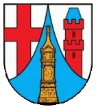
| Arms | Map |
|---|---|

|

|
| Country: | Germany |
| State: | Rhineland-Palatinate |
| District: | Trier-Saarburg |
| Verbandsgemeinde: | Trier-Land |
Trier-Land is a Verbandsgemeinde ("collective municipality") in the Trier-Saarburg district, in Rhineland-Palatinate, Germany. It is situated on the border with Luxembourg, north and west of Trier. The seat of the municipality is in Trier, itself not part of the municipality.
The Verbandsgemeinde Trier-Land consists of the following Ortsgemeinden ("local municipalities"):
International relations
Twin towns — sister cities
Trier-Land is twinned with:
References
- ^ "Podolsk sister cities". Translate.google.com. Retrieved 2010-04-29.
49°45′40″N 6°33′17″E / 49.76111°N 6.55472°E


