Adiralu: Difference between revisions
Tools
Actions
General
Print/export
In other projects
Appearance
From Wikipedia, the free encyclopedia
m en-IN |
|||
| Line 1: | Line 1: | ||
{{Use dmy dates|date=September 2018}} |
|||
{{Use Indian English|date=September 2018}} |
|||
{{Infobox settlement |
{{Infobox settlement |
||
| name = Adiralu |
| name = Adiralu |
||
Revision as of 01:20, 7 September 2018
Village in Karnataka, India
Adiralu | |
|---|---|
village | |
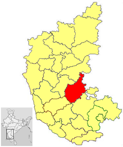
 Adiralu is in Chitradurga district | |
 | |
| Country | |
| State | Karnataka |
| District | Chitradurga |
| Talukas | Hiriyur |
| Government | |
| • Body | Village Panchayat |
| Languages | |
| • Official | Kannada |
| Time zone | UTC+5:30 (IST) |
| Nearest city | Chitradurga |
| Civic agency | Village Panchayat |
Adiralu is a village in the southern state of Karnataka, India.[1][2] It is located in the Hiriyur taluk of Chitradurga district in Karnataka.
See also
References
- ^ "Census of India : List of Villages Alphabetical Order > Karnataka". Registrar General & Census Commissioner, India. Retrieved 18 December 2008.[permanent dead link] , Census Village code= 1032200
- ^ "Yahoo! maps India :". Archived from the original on 14 January 2009. Retrieved 17 April 2009.
{{cite web}}: Unknown parameter|deadurl=ignored (|url-status=suggested) (help) Adiralu, Chitradurga, Karnataka
14°03′N 76°31′E / 14.050°N 76.517°E / 14.050; 76.517
This article related to a location in Chitradurga district, Karnataka, India is a stub. You can help Wikipedia by expanding it. |
Hidden categories:
- All articles with dead external links
- Articles with dead external links from October 2016
- Articles with permanently dead external links
- CS1 errors: unsupported parameter
- Pages using gadget WikiMiniAtlas
- Use dmy dates from September 2018
- Use Indian English from September 2018
- All Wikipedia articles written in Indian English
- Articles with short description
- Short description matches Wikidata
- Infobox mapframe without OSM relation ID on Wikidata
- Pages using infobox settlement with no map
- Pages using infobox settlement with no coordinates
- Coordinates on Wikidata
- All stub articles
- Pages using the Kartographer extension
