Nadakkavu: Difference between revisions
no refs |
m Dating maintenance tags: {{Unsourced}} |
||
| Line 1: | Line 1: | ||
{{unsourced}} |
{{unsourced|date=October 2018}} |
||
{{Use dmy dates|date=October 2018}} |
{{Use dmy dates|date=October 2018}} |
||
{{Use Indian English|date=October 2018}} |
{{Use Indian English|date=October 2018}} |
||
Revision as of 01:15, 28 October 2018
Kozhikode Nadakkavu | |
|---|---|
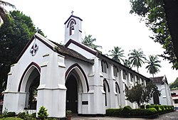
 St.Mary's English Church, Nadakkavu | |
 | |
| Coordinates: 11°16′17″N 75°46′46″E / 11.27126°N 75.77953°E | |
| Country | India |
| State | Kerala |
Nadakkavu is a commercial and residential town of Kozhikode city. It is about three kilometers from the city center. Areas like Chakkorath Kulam, Vandipettah, Bilathikkulam and Kanakalaya are part of Nadakkavu. The suburb of Nadakkavu is further connected to West Hill area with the government guest house and the polytechnic situated inside the locality. There is a helipad in West Hill and the road to the beach is called Bhatt Road. The road to the north takes you to Puthiyangadi, Pavangad, Kozhikode, Elathur and Koyilandy. 11°16′23″N 75°46′45″E / 11.27301°N 75.77919°E
Transportation
The road from Mananchira to the north of city connects directly to Nadakkavu suburb. The offices of Malayala Manorama newspaper and Chandrika newspaper are located here. The ancient English Church and Panicker Road are connected to Nadakkavu on the beach side. On the northern side of the Nadakkavu town, the office of the Post Master General and the C.H.Mosque Eranhipalam are located. Eranhipalam is connected to Nadakkavu by the Kottaram Road which diverts to form the U.G.Nayak Road near the Homeo Hospital. The road going to the east from Homeo Hospital takes you to Jawahar Nagar near Sarovaram Bio Park.

Important Organizations
- Girls Higher Secondary School, Nadakkavu
- Infanat Jesus Church, Ashokapuram
- IHRD Applied Science College, Ashokapuram
- Rajendhra Nursing Home, Ashokapuram
- Marx Engels Bhawan,Ashokapuram
- Kuniyil Kavu Temple, Jafferkhan colony
