Iténez Province: Difference between revisions
Appearance
Content deleted Content added
Rescuing 1 sources and tagging 0 as dead. #IABot (v1.3beta6) |
No edit summary |
||
| Line 1: | Line 1: | ||
{{Infobox |
{{Infobox settlement |
||
<!-- See Template:Infobox settlement for additional fields and descriptions --> |
|||
|name =Iténez |
|name =Iténez |
||
|settlement_type =Province <!--For Town or Village (Leave blank for the default City)--> |
|settlement_type =Province <!--For Town or Village (Leave blank for the default City)--> |
||
Revision as of 00:32, 24 November 2018
Iténez | |
|---|---|
Province | |
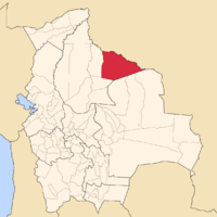
 Map of Bolivia highlighting the province of Iténez. | |
 Provinces of the Beni Department | |
| Country | |
| Departament | Beni |
| Settlements | |
| Area | |
• Total | 14,122 sq mi (36,576 km2) |
| Population (2006)[1] | |
• Total | 20,190 |
| • Density | 1.4/sq mi (0.55/km2) |
| Time zone | UTC-4 (GMT -4) |
Iténez is a province in the Beni Department, Bolivia.
References
- ^ www.ine.gov.bo Archived 2009-11-13 at the Wayback Machine - Instituto Nacional de Estadística de Bolivia Template:Es icon

