Spangereid: Difference between revisions
m →Name: "this this" to "This" |
No edit summary |
||
| Line 1: | Line 1: | ||
{{about|the former municipality in Vest-Agder, Norway|the village in Lindesnes, Norway|Høllen, Lindesnes}} |
{{about|the former municipality in Vest-Agder, Norway|the village in Lindesnes, Norway|Høllen, Lindesnes}} |
||
{{Infobox |
{{Infobox settlement |
||
<!-- See Template:Infobox settlement for additional fields and descriptions --> |
|||
|name = Spangereid herred |
|name = Spangereid herred |
||
|settlement_type = [[List of former municipalities of Norway|Former Municipality]] |
|settlement_type = [[List of former municipalities of Norway|Former Municipality]] |
||
Revision as of 04:05, 26 November 2018
Spangereid herred | |
|---|---|
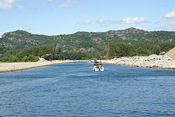
 View of the Spangereid canal | |
| Coordinates: 58°02′42″N 07°08′34″E / 58.04500°N 7.14278°E | |
| Country | Norway |
| Region | Southern Norway |
| County | Vest-Agder |
| District | Sørlandet |
| Municipality ID | NO-1030 |
| Adm. Center | Høllen |
| Time zone | UTC+01:00 (CET) |
| • Summer (DST) | UTC+02:00 (CEST) |
| Created from | Sør-Undal in 1889 |
| Merged into | Lindesnes in 1964 |
Spangereid is a former municipality in Vest-Agder county, Norway. The municipality existed from 1889 until its dissolution in 1964. The municipality was located in the southwestern part of the present-day municipality of Lindesnes. The municipality included the whole Lindesnes peninsula, plus part of the mainland adjacent to the narrow isthmus which connects the peninsula to the mainland. The administrative centre was the village of Høllen where the Spangereid Church is located.[1]
The area is one of Norway's richest archaeological sites. The abundant remnants from the Bronze Age and Viking age show the Spangereid was a very important place at that time. Spangereid is strategically connected at the Lindesnes peninsula, Norway's southernmost point, where the east coast meets the west coast.
Name
The municipality (originally the parish) was named after the old Spangereid farm (Old Norse: Spangarheiði). This is where the local Spangereid Church was located. The first element comes from the Old Norse word spǫng which means a "small piece of land" and the last element is eið which is identical with the word for "isthmus", since the church is located on an isthmus which connects the Lindesnes peninsula to the mainland.[2][1]
History
The municipality of Spangereid was established on 1 January 1899 when it was separated from the municipality of Sør-Undal. The initial population of the new municipality was 1,734. During the 1960s, there were many municipal mergers across Norway due to the work of the Schei Committee. On 1 January 1963, the Gitlevåg area (population: 103) of Spangereid was transferred to the neighboring municipality of Lyngdal. On 1 January 1964, Spangereid (population: 899) was merged with Sør-Audnedal and Vigmostad to form the new municipality of Lindesnes.[3]
Photo gallery
-
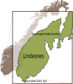
Map of the Spangereid area
-
Central part of Høllen
References
- ^ a b Store norske leksikon. "Spangereid – tidligere kommune" (in Norwegian). Retrieved 2016-12-08.
- ^ Rygh, Oluf (1912). Norske gaardnavne: Lister og Mandals amt (in Norwegian) (9 ed.). Kristiania, Norge: W. C. Fabritius & sønners bogtrikkeri. p. 173.
- ^ Jukvam, Dag (1999). "Historisk oversikt over endringer i kommune- og fylkesinndelingen" (PDF) (in Norwegian). Statistisk sentralbyrå.
External links
 Vest-Agder travel guide from Wikivoyage
- Informational webside about Spangereid Template:No icon


