Es Cubells: Difference between revisions
Appearance
Content deleted Content added
m Reverted edits by 98.0.162.70 (talk) to last version by Suelru |
m →top: replaced: Village → village |
||
| Line 19: | Line 19: | ||
|pushpin_label_position =bottom |
|pushpin_label_position =bottom |
||
|pushpin_mapsize= |
|pushpin_mapsize= |
||
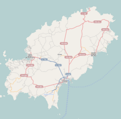
|pushpin_map_caption =Location of the |
|pushpin_map_caption =Location of the village in Ibiza |
||
|subdivision_type = Country |
|subdivision_type = Country |
||
|subdivision_name ={{flag|Spain}} |
|subdivision_name ={{flag|Spain}} |
||
Revision as of 23:24, 19 December 2018
Es Cubells | |
|---|---|
Village | |
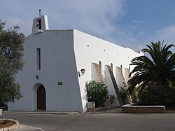
 The Church at Es Cubells | |
| Coordinates: 38°52′45″N 1°16′19″E / 38.87917°N 1.27194°E | |
| Country | |
| Region | Balearic Islands |
| Population (2006) | |
• Total | 807 |
| Time zone | UTC+1 (CET) |
| • Summer (DST) | UTC+2 (CEST) |
Es Cubells is a small village in the south west of the Spanish island of Ibiza.[1] The village is in the municipality of Sant Josep de sa Talaia. The village is reached along the designated road PMV 803-1. The village is 10.6 miles (17.1 km) south west of Ibiza Town and 8.1 miles (13.0 km) of Ibiza Airport.[1]
References
- ^ a b "579 Regional Map, Spain, Islas Baleares. Pub:Michelin Editions des Voyages, 2004, ISBN 2-06-710098-X

