Cunel: Difference between revisions
Appearance
Content deleted Content added
m canton using AWB |
m Robot - Speedily moving category Communes of Meuse to Category:Communes of Meuse (department) per CFDS. |
||
| Line 28: | Line 28: | ||
{{Meuse communes}} |
{{Meuse communes}} |
||
[[Category:Communes of Meuse]] |
[[Category:Communes of Meuse (department)]] |
||
Revision as of 17:42, 30 December 2018
Cunel | |
|---|---|
| Coordinates: 49°20′12″N 5°07′02″E / 49.3367°N 5.1172°E | |
| Country | France |
| Region | Grand Est |
| Department | Meuse |
| Arrondissement | Verdun |
| Canton | Clermont-en-Argonne |
| Intercommunality | Communauté de communes du Val Dunois |
| Government | |
| • Mayor (2008–2014) | Pierre Sibille |
Area 1 | 4.69 km2 (1.81 sq mi) |
| Population (1999) | 18 |
| • Density | 3.8/km2 (9.9/sq mi) |
| Time zone | UTC+01:00 (CET) |
| • Summer (DST) | UTC+02:00 (CEST) |
| INSEE/Postal code | 55140 /55110 |
| Elevation | 224–301 m (735–988 ft) (avg. 260 m or 850 ft) |
| 1 French Land Register data, which excludes lakes, ponds, glaciers > 1 km2 (0.386 sq mi or 247 acres) and river estuaries. | |
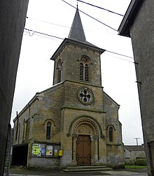
Cunel is a commune in the Meuse department in Grand Est in north-eastern France.
See also

Wikimedia Commons has media related to Cunel.


