Zelenikovo Municipality: Difference between revisions
Appearance
Content deleted Content added
mNo edit summary |
mNo edit summary |
||
| Line 27: | Line 27: | ||
}} |
}} |
||
'''Zelenikovo Municipality''' ({{lang-mk|{{Audio|Mk-Zelenikovo.ogg|Зелениково}}}}, {{lang-sq|Zelenikovë}}) is a municipality in central part of [[Republic of Macedonia]]. The municipal seat is located in the village [[Zelenikovo, Macedonia|Zelenikovo]]. The municipality is located in the [[Skopje Statistical Region]]. |
'''Zelenikovo Municipality''' ({{lang-mk|{{Audio|Mk-Zelenikovo.ogg|Зелениково}}}}, {{lang-sq|Zelenikovë}}) is a municipality in the central part of the [[North Macedonia|Republic of North Macedonia]]. The municipal seat is located in the village [[Zelenikovo, Macedonia|Zelenikovo]]. The municipality is located in the [[Skopje Statistical Region]]. |
||
==Geography== |
==Geography== |
||
Revision as of 17:18, 20 February 2019
Municipality of Zelenikovo
Општина Зелениково Komuna e Zelenikovës | |
|---|---|
Rural municipality | |
 | |
| Country | |
| Region | Skopje Statistical Region |
| Municipal seat | Zelenikovo |
| Government | |
| • Mayor | Vele Gruevski (VMRO-DPMNE) |
| Area | |
• Total | 176.95 km2 (68.32 sq mi) |
| Population (2002) | |
• Total | 4,077 |
| • Density | 23/km2 (60/sq mi) |
| Time zone | UTC+1 (CET) |
| Area code | 02 |
| Car Plates | SK |
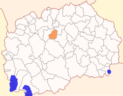
Zelenikovo Municipality (Template:Lang-mk, Template:Lang-sq) is a municipality in the central part of the Republic of North Macedonia. The municipal seat is located in the village Zelenikovo. The municipality is located in the Skopje Statistical Region.
Geography
The municipality borders Studeničani Municipality to the west, Petrovec Municipality to the northeast, Čaška Municipality to the south, and Veles Municipality to the southeast.
Demographics
According to the 2002 Macedonian census, Zelenikovo Municipality has 4,077 inhabitants.[1] Ethnic groups in the municipality:
- Macedonians = 2,522 (61.9%)
- Albanians = 1,206 (29.6%)
- Bosniaks = 191 (4.7%)
- Turks = 1 (<0.1%)
- others.
References
- ^ 2002 census results in English and Macedonian (PDF)
