Blandas: Difference between revisions
KylieTastic (talk | contribs) invalid image |
|||
| Line 175: | Line 175: | ||
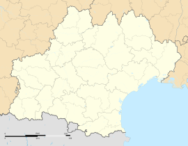
| caption = map of Megaliths in Blandas (Gard), France |
| caption = map of Megaliths in Blandas (Gard), France |
||
| label = 1 |
| label = 1 |
||
|mark1 = solid black 17.gif |
|mark1 = X solid black 17.gif |
||
| marksize = 8 |
| marksize = 8 |
||
| pos = right |
| pos = right |
||
| coordinates = {{coord|43.9261| 3.5306|name=Cromlech de Lacam de Peyrarines}} |
| coordinates = {{coord|43.9261| 3.5306|name=Cromlech de Lacam de Peyrarines}} |
||
| label2 = 2 |
| label2 = 2 |
||
| mark2 = solid black 17.gif |
| mark2 = X solid black 17.gif |
||
| mark2size = 8 |
| mark2size = 8 |
||
| pos2 = right |
| pos2 = right |
||
| coordinates2 = {{coord|43.9272| 3.4914|name=Cromlech de Lacam de la Rigalderie}} |
| coordinates2 = {{coord|43.9272| 3.4914|name=Cromlech de Lacam de la Rigalderie}} |
||
| label3 = 3 |
| label3 = 3 |
||
| mark3 = solid black 17.gif |
| mark3 = X solid black 17.gif |
||
| mark3size = 8 |
| mark3size = 8 |
||
| pos3 = right |
| pos3 = right |
||
| coordinates3 = {{coord|43.8942| 3.5638|name=Cromlech de Lacam de Rogues}} |
| coordinates3 = {{coord|43.8942| 3.5638|name=Cromlech de Lacam de Rogues}} |
||
| label4 = 4 |
| label4 = 4 |
||
| mark4 = solid black 17.gif |
| mark4 = X solid black 17.gif |
||
| mark4size = 8 |
| mark4size = 8 |
||
| pos4 = right |
| pos4 = right |
||
| coordinates4 = {{coord|43.9377| 3.5032|name=Dolmen d'Arques}} |
| coordinates4 = {{coord|43.9377| 3.5032|name=Dolmen d'Arques}} |
||
| label5 = 5 |
| label5 = 5 |
||
| mark5 = solid black 17.gif |
| mark5 = X solid black 17.gif |
||
| mark5size = 8 |
| mark5size = 8 |
||
| pos5 = right |
| pos5 = right |
||
| coordinates5 = {{coord|43.9127| 3.5541|name=Dolmen de Barral}} |
| coordinates5 = {{coord|43.9127| 3.5541|name=Dolmen de Barral}} |
||
| label6 = 6 |
| label6 = 6 |
||
| mark6 = solid black 17.gif |
| mark6 = X solid black 17.gif |
||
| mark6size = 8 |
| mark6size = 8 |
||
| pos6 = right |
| pos6 = right |
||
| coordinates6 = {{coord|43.8936| 3.5367|name=Dolmen de la Borie d'Arre}} |
| coordinates6 = {{coord|43.8936| 3.5367|name=Dolmen de la Borie d'Arre}} |
||
| label7 = 7 |
| label7 = 7 |
||
| mark7 = solid black 17.gif |
| mark7 = X solid black 17.gif |
||
| mark7size = 8 |
| mark7size = 8 |
||
| pos7 = right |
| pos7 = right |
||
| coordinates7 = {{coord|43.9282| 3.5366|name=Dolmen de Planas}} |
| coordinates7 = {{coord|43.9282| 3.5366|name=Dolmen de Planas}} |
||
| label8 = 8 |
| label8 = 8 |
||
| mark8 = solid black 17.gif |
| mark8 = X solid black 17.gif |
||
| mark8size = 8 |
| mark8size = 8 |
||
| pos8 = right |
| pos8 = right |
||
| coordinates8 = {{coord|43.9207| 3.5427|name=Dolmen de Regos}} |
| coordinates8 = {{coord|43.9207| 3.5427|name=Dolmen de Regos}} |
||
| label9 = 9 |
| label9 = 9 |
||
| mark9 = solid black 17.gif |
| mark9 = X solid black 17.gif |
||
| mark9size = 8 |
| mark9size = 8 |
||
| pos9 = right |
| pos9 = right |
||
| coordinates9 = {{coord|43.9115| 3.5374|name=Dolmen du Château d'Assas}} |
| coordinates9 = {{coord|43.9115| 3.5374|name=Dolmen du Château d'Assas}} |
||
| label10 = 10 |
| label10 = 10 |
||
| mark10 = solid black 17.gif |
| mark10 = X solid black 17.gif |
||
| mark10size = 8 |
| mark10size = 8 |
||
| pos10 = right |
| pos10 = right |
||
| coordinates10 = {{coord|43.9357|3.4934|name=Menhirs d'Avernat}} |
| coordinates10 = {{coord|43.9357|3.4934|name=Menhirs d'Avernat}} |
||
| label11 = 11 |
| label11 = 11 |
||
| mark11 = solid black 17.gif |
| mark11 = X solid black 17.gif |
||
| mark11size = 8 |
| mark11size = 8 |
||
| pos11 = right |
| pos11 = right |
||
| coordinates11 = {{coord|43.9359| 3.4958|name=Menhir des Combes}} |
| coordinates11 = {{coord|43.9359| 3.4958|name=Menhir des Combes}} |
||
| label12 = 12 |
| label12 = 12 |
||
| mark12 = solid black 17.gif |
| mark12 = X solid black 17.gif |
||
| mark12size = 8 |
| mark12size = 8 |
||
| pos12 = right |
| pos12 = right |
||
| coordinates12 = {{coord|43.9266| 3.5391|name=Menhir de Planas}} |
| coordinates12 = {{coord|43.9266| 3.5391|name=Menhir de Planas}} |
||
| label13 = 13 |
| label13 = 13 |
||
| mark13 = solid black 17.gif |
| mark13 = X solid black 17.gif |
||
| mark13size = 8 |
| mark13size = 8 |
||
| pos13 = right |
| pos13 = right |
||
| coordinates13 = {{coord|43.9262| 3.5215|name=Menhir du Sotch des Genièvres}} |
| coordinates13 = {{coord|43.9262| 3.5215|name=Menhir du Sotch des Genièvres}} |
||
| label14 = 14 |
| label14 = 14 |
||
| mark14 = solid black 17.gif |
| mark14 = X solid black 17.gif |
||
| mark14size = 8 |
| mark14size = 8 |
||
| pos14 = right |
| pos14 = right |
||
| coordinates14 = {{coord|43.9365| 3.5162|name=Menhir de Landre}} |
| coordinates14 = {{coord|43.9365| 3.5162|name=Menhir de Landre}} |
||
| label15 = 15 |
| label15 = 15 |
||
| mark15 = solid black 17.gif |
| mark15 = X solid black 17.gif |
||
| mark15size = 8 |
| mark15size = 8 |
||
| pos15 = right |
| pos15 = right |
||
| Line 255: | Line 255: | ||
*[[Causse de Blandas]] |
*[[Causse de Blandas]] |
||
*[[Cirque de Navacelles]] |
*[[Cirque de Navacelles]] |
||
==References== |
==References== |
||
*[http://www.insee.fr/en/home/home_page.asp INSEE] |
*[http://www.insee.fr/en/home/home_page.asp INSEE] |
||
Revision as of 17:59, 22 March 2019
Blandas | |
|---|---|
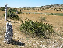
 Part of the Rigalderie stone circle in Blandas | |
| Coordinates: 43°54′49″N 3°30′49″E / 43.9136°N 3.5136°E | |
| Country | France |
| Region | Occitania |
| Department | Gard |
| Arrondissement | Le Vigan |
| Canton | Le Vigan |
| Intercommunality | Pays Viganais |
| Government | |
| • Mayor (2015-2020) | Jean-Claude Gonzalez Trique |
Area 1 | 37.46 km2 (14.46 sq mi) |
| Population (2008) | 128 |
| • Density | 3.4/km2 (8.8/sq mi) |
| Time zone | UTC+01:00 (CET) |
| • Summer (DST) | UTC+02:00 (CEST) |
| INSEE/Postal code | 30040 /30770 |
| Elevation | 280–953 m (919–3,127 ft) (avg. 650 m or 2,130 ft) |
| 1 French Land Register data, which excludes lakes, ponds, glaciers > 1 km2 (0.386 sq mi or 247 acres) and river estuaries. | |
Blandas is a commune in the Gard department in southern France. It is known for its proximity to the Cirque de Navacelles and the town encompasses one of the principal overlooks on the Cirque. It is also for its exceptional megalithic sites. It is included in the UNESCO world heritage site "The Causses and the Cévennes, Mediterranean agro-pastoral Cultural Landscape"[1][2]
Population
| Year | Pop. | ±% |
|---|---|---|
| 1881 | 528 | — |
| 1891 | 506 | −4.2% |
| 1901 | 420 | −17.0% |
| 1911 | 355 | −15.5% |
| 1921 | 268 | −24.5% |
| 1931 | 268 | +0.0% |
| 1936 | 227 | −15.3% |
| 1954 | 196 | −13.7% |
| 1962 | 172 | −12.2% |
| 1968 | 141 | −18.0% |
| 1975 | 115 | −18.4% |
| 1982 | 116 | +0.9% |
| 1990 | 112 | −3.4% |
| 1999 | 106 | −5.4% |
| 2008 | 128 | +20.8% |
History
Prehistoric Finds
La grotte des Pins
In may, 1967 a team of speleologues attempted to enlarge a natural opening exposed by erosion. Their work exposed a large hidden room 5m high and on the floor of the room they found fragments of ceramics. Further exploration uncovered tools, objects, and much scattered charcoal, up to 60cm thick in places possibly from prehistoric torches. Theories at the time suggested that the cave served as a cellar or storage, rather than a habitation, since a lack of air circulation made hearth fires difficult.[3]
Baume du Roc du Midi
In 1979 at Baume du Roc du Midi, a cave which opens out from the cliff on the edge of the causse de Blandas at a lookout with a view over the Cirque de Navacelles, archeologists discovered a walled part of the cave, closed since the middle ages, but inhabited continuously from prehistory into protohistoric times. Inside the walled portion, many objects including two copper daggers with serrated blades, a bronze axe, a rivited bronze dagger, bronze sconces, spear-tips, and many other Bronze Age objects[4]
La Baumelle
A discovery was made in 2009[5] by speleologists in a prehistoric cave which had been blocked for over 5000 years. On August 10 2009, speleologists, along with Laurent Bruxelles and Philippe Galant, from Institut national de Recherches archéologiques préventives, began a 10 day exploration of the find. The entrance was blocked by a menhir or stele. This sandstone monolith with engraved surface had been moved from a deposit found at Montdardier 5-6 km from the cave. Prehistoric remains were discovered: skulls, some covered in calcite, pieces of water-collecting vessels, ceramic shards, and a furnished hallway.[6]
Megaliths
see also Mégalithes du causse de Blandas (fr)
See also
References
- ^ https://whc.unesco.org/en/list/1153
- ^ https://blandas.fr/
- ^ Template:Cite article
- ^ Documents préhistoriques de la grotte du Roc du Midi (Blandas, Gard) (article) J.-L. Roudil;P. Vincent; Bulletin de la Société préhistorique française Year 1974 vol71 n7 pp.203-209
- ^ https://www.ladepeche.fr/article/2009/10/04/686673-gard-la-grotte-aux-miracles.html
- ^ Galant, Philippe & Villemejeanne, Richard & Etienne, Aurélien & Bruxelles, Laurent & Boschi, Jean-Yves. (2012). 2015 - Découverte de deux stèles en contexte Néolithique final sur le site de la Baumelle à Blandas (Gard).
- ^ https://www.megalithic.co.uk/article.php?sid=6334839
- ^ https://blandas.fr/tourisme-loisirs/lieux-de-curiosites/cromlech-de-perrarines/
- ^ https://www.megalithic.co.uk/article.php?sid=6334837


