Bisley, Gloucestershire: Difference between revisions
→Notable residents: tense |
m re-doing images with copyright tags |
||
| Line 38: | Line 38: | ||
Bisley has a structure on Wells Road, containing seven spouts forming a public water supply from the Seven Springs and is known for its well dressing.<ref>{{cite web|url=http://www.glosgen.co.uk/records/bisley.htm|title=GlosGen - Bisley Genealogy|website=www.glosgen.co.uk}}</ref> |
Bisley has a structure on Wells Road, containing seven spouts forming a public water supply from the Seven Springs and is known for its well dressing.<ref>{{cite web|url=http://www.glosgen.co.uk/records/bisley.htm|title=GlosGen - Bisley Genealogy|website=www.glosgen.co.uk}}</ref> |
||
There is a Saxon wayside cross on the wide verge of Bisley Road, south-west of Stancombe Toll House. |
There is a Saxon wayside cross on the wide verge of Bisley Road, south-west of Stancombe Toll House. [[File:StancombeTollHouse.jpg|thumb|150px|'''''Stancombe Toll House''''']] |
||
[[File:WaysideCross.jpg|thumb|left|150px|'''''the Cross-Shaft''''']] [[File:WaysideCross2.jpg|thumb|left|150px|'''''the plaque''''']] |
|||
[[File:Bisley Church - geograph.org.uk - 786958.jpg|thumb|The church of All Saints; it was mostly rebuilt in the early 1860s, however, it may have originally been an Anglo-Saxon minister]] |
[[File:Bisley Church - geograph.org.uk - 786958.jpg|thumb|The church of All Saints; it was mostly rebuilt in the early 1860s, however, it may have originally been an Anglo-Saxon minister]] |
||
Revision as of 12:10, 17 April 2019
| Bisley | |
|---|---|
 A view over Bisley | |
Location within Gloucestershire | |
| Population | 2,142 (2011)[1] |
| OS grid reference | SO905065 |
| Civil parish | |
| District | |
| Shire county | |
| Region | |
| Country | England |
| Sovereign state | United Kingdom |
| Post town | Stroud |
| Postcode district | GL6 |
| Police | Gloucestershire |
| Fire | Gloucestershire |
| Ambulance | South Western |
| UK Parliament | |
Bisley is a village in Gloucestershire, England, about 4 miles (6 km) east of Stroud. The parish is combined with adjoining Lypiatt, the two being styled Bisley-with-Lypiatt. The once-extensive manor included Stroud and Chalford, Thrupp, Oakridge, Bussage, Througham and Eastcombe.
Governance
An electoral ward in the name Bisley exists. This ward has the same area and population as the civil parish.
History and architecture
The area is noted for the wealth of its Cotswold stone houses of architectural and historic interest.[2] They include Lypiatt Park, formerly the home of Judge H. B. D. Woodcock and then of the late Modernist sculptor Lynn Chadwick;[3] Nether Lypiatt Manor, formerly the home of Violet Gordon-Woodhouse and Prince and Princess Michael of Kent;[4] Daneway (near Sapperton, but within the parish of Bisley); Over Court; Througham Court (repaired in 1929 for the novelist Sir Michael Sadleir by Norman Jewson);[5] and Jaynes Court, formerly the private residence of Simon Isaacs, 4th Marquess of Reading (b. 1942).

Througham Slad Manor is believed to date from the mid 16th century with 18th century additions, the manor was altered in the 1930s by Norman Jewson for W. A. Cadbury. In the 1970s, the house was owned by Mike Oldfield, who installed a recording studio in the barn.
The village prison, which had originally been located in the Church yard, was replaced in 1824 by a two-cell lock-up where drunks were kept overnight,[6] and petty criminals were detained before appearing before the magistrate. This was often followed by a spell in the stocks or pillory. This building still stands, minus its heavy oak doors.
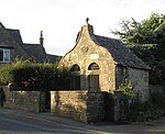
Bisley has a structure on Wells Road, containing seven spouts forming a public water supply from the Seven Springs and is known for its well dressing.[7]
There is a Saxon wayside cross on the wide verge of Bisley Road, south-west of Stancombe Toll House.


Notable residents
- Denis Parsons Burkitt, surgeon and cancer researcher, lived latterly in Bisley and was buried there in 1993.[8]
- Bisley since 1982 has been the home of Jilly Cooper,[9] a prolific contemporary novelist, and was that of her husband, the publisher Leo Cooper, until his death in 2013.
See also
References
- ^ "Parish population 2011". Retrieved 28 March 2015.
- ^ Stroud Council Conservation Area No. 6 Bisley Archived 23 July 2011 at the Wayback Machine
- ^ "British Council". Archived from the original on 25 July 2011. Retrieved 30 June 2009.
{{cite web}}: Unknown parameter|dead-url=ignored (|url-status=suggested) (help) - ^ "BBC - Gloucestershire The Royal County - Nether Lypiatt Manor". www.bbc.co.uk.
- ^ "Bisley: Introduction - British History Online". www.british-history.ac.uk.
- ^ GlosGen - Bisley Archived 4 March 2009 at the Wayback Machine
- ^ "GlosGen - Bisley Genealogy". www.glosgen.co.uk.
- ^ Anthony Epstein, "Burkitt, Denis Parsons (1911–1993)", Oxford Dictionary of National Biography (Oxford, UK: OUP, 2004. Retrieved 28 February 2017, pay-walled.
- ^ Clarke, Jeremy (26 March 2006). "'Jillywood' tours target Cotswolds' reluctant celebrities" – via www.telegraph.co.uk.

