Ganochora: Difference between revisions
Appearance
Content deleted Content added
JJMC89 bot (talk | contribs) Migrate {{Infobox Greek Dimos}} coordinates parameters to {{Coord}}, see Wikipedia:Coordinates in infoboxes |
No edit summary |
||
| Line 13: | Line 13: | ||
|elevation = 65 |
|elevation = 65 |
||
|coordinates = {{coord|40|18.5|N|22|30|E|format=dms|display=inline,title}} |
|coordinates = {{coord|40|18.5|N|22|30|E|format=dms|display=inline,title}} |
||
|postal_code = 601 |
|postal_code = 601 50 |
||
|area_code = +302351-xxx-xxx |
|area_code = +302351-xxx-xxx |
||
|licence = KN |
|licence = KN |
||
Revision as of 16:58, 14 July 2019
Ganochora
Γανόχωρα | |
|---|---|
Settlement | |
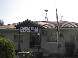
 The community hall of Ganochora | |
| Coordinates: 40°18.5′N 22°30′E / 40.3083°N 22.500°E | |
| Country | Greece |
| Administrative region | Central Macedonia |
| Regional unit | Pieria |
| Municipality | Katerini |
| Municipal unit | Katerini |
| Elevation | 65 m (213 ft) |
| Population (2011)[1] | |
| • Community | 799 |
| Time zone | UTC+2 (EET) |
| • Summer (DST) | UTC+3 (EEST) |
| Postal code | 601 50 |
| Area code(s) | +302351-xxx-xxx |
| Vehicle registration | KN |
Ganochora (Template:Lang-el) is a village and a community of the Katerini municipality.[2] Before the 2011 local government reform it was part of the municipality of Katerini, of which it was a municipal district.[2] The 2011 census recorded 799 inhabitants in the village.[1]
History
Ganochora was established by refugees from the cities in Eastern Thrace: Ganos and Chora that settled in the area after the population exchange between Greece and Turkey in 1922.
See also
References
- ^ a b "Απογραφή Πληθυσμού - Κατοικιών 2011. ΜΟΝΙΜΟΣ Πληθυσμός" (in Greek). Hellenic Statistical Authority.
- ^ a b Kallikratis law Greece Ministry of Interior Template:El icon

