Eggishorn: Difference between revisions
Appearance
Content deleted Content added
Rescuing 1 sources and tagging 0 as dead. #IABot (v2.0beta15) |
No edit summary |
||
| Line 1: | Line 1: | ||
{{Infobox mountain |
{{Infobox mountain |
||
| name = Eggishorn |
| name = Eggishorn |
||
| photo = |
| photo = Eggishorn, Berner Alpen, Wallis, Switzerland, from southwest.jpg |
||
| photo_size = 285 |
| photo_size = 285 |
||
| photo_caption = Eggishorn viewed from |
| photo_caption = Eggishorn viewed from southwest |
||
| elevation_m = 2927 |
| elevation_m = 2927 |
||
| elevation_ref = |
| elevation_ref = |
||
| Line 25: | Line 25: | ||
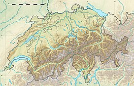
The '''Eggishorn''' is a [[mountain]] of the [[Bernese Alps]], located north of [[Fiesch]] in the Swiss canton of [[Valais]]. A cable car station is located on a secondary summit named ''Fiescherhorli'' (2,893 m), 500 metres south of the main peak. |
The '''Eggishorn''' is a [[mountain]] of the [[Bernese Alps]], located north of [[Fiesch]] in the Swiss canton of [[Valais]]. A cable car station is located on a secondary summit named ''Fiescherhorli'' (2,893 m), 500 metres south of the main peak. |
||
The Eggishorn lies within the [[Jungfrau-Aletsch-Bietschhorn]] region, which |
The Eggishorn lies within the [[Jungfrau-Aletsch-Bietschhorn]] region, which in 2001 was designated by [[UNESCO]] as a [[World Heritage Site]]. On its northern flank is the [[Aletsch Glacier]]. From the summit the view extends also to the [[Lepontine Alps|Lepontine]] and [[Pennine Alps]] ([[Dom (Mischabel)|Dom]], [[Matterhorn]], [[Weisshorn]]). |
||
==Pictures== |
==Pictures== |
||
| Line 32: | Line 33: | ||
Image:Eggishorn summit.jpg|Eggishorn Terminus {{convert|2926|m|ft|0}} |
Image:Eggishorn summit.jpg|Eggishorn Terminus {{convert|2926|m|ft|0}} |
||
Image:Eggishorn 83.JPG|Aerial tramway Fiesch Eggishorn (FE) |
Image:Eggishorn 83.JPG|Aerial tramway Fiesch Eggishorn (FE) |
||
Image:Eggishorn, Schuttfeld unterr dem Gipfel.jpg|Gipfel des Eggishorns mit Schuttfeld unterhalb |
|||
</gallery> |
</gallery> |
||
==See also== |
==See also== |
||
Revision as of 11:14, 12 August 2019
| Eggishorn | |
|---|---|
 Eggishorn viewed from southwest | |
| Highest point | |
| Elevation | 2,927 m (9,603 ft) |
| Prominence | 563 m (1,847 ft)[1] |
| Parent peak | Finsteraarhorn |
| Listing | Alpine mountains 2500-2999 m |
| Coordinates | 46°25′53″N 8°05′39″E / 46.43139°N 8.09417°E |
| Geography | |
| Location | Valais, Switzerland |
| Parent range | Bernese Alps |
| Climbing | |
| Easiest route | Aerial tramway |
The Eggishorn is a mountain of the Bernese Alps, located north of Fiesch in the Swiss canton of Valais. A cable car station is located on a secondary summit named Fiescherhorli (2,893 m), 500 metres south of the main peak.
The Eggishorn lies within the Jungfrau-Aletsch-Bietschhorn region, which in 2001 was designated by UNESCO as a World Heritage Site. On its northern flank is the Aletsch Glacier. From the summit the view extends also to the Lepontine and Pennine Alps (Dom, Matterhorn, Weisshorn).
Pictures
-
Eggishorn Terminus 2,926 metres (9,600 ft)
-
Aerial tramway Fiesch Eggishorn (FE)
-
Gipfel des Eggishorns mit Schuttfeld unterhalb
See also
References
- ^ Retrieved from the Swisstopo topographic maps. The key col is located east of the Märjelensee at 2,364 metres.
External links
Wikimedia Commons has media related to Eggishorn.
- Eggishorn on Summitpost
- Eggishorn on Hikr
- Eggishorn, the mountain of views
- Fiesch Eggishorn cable car (FE)


