Mainland, Shetland: Difference between revisions
Appearance
Content deleted Content added
m over linking |
|||
| Line 1: | Line 1: | ||
{{Infobox Scottish island | |
{{Infobox Scottish island | |
||
|Map=Shetland Mainland locator.svg |
|Map=Shetland Mainland locator.svg |
||
|official_name=Mainland |
|||
|Image= |
|||
|Image=Lerwick square.jpg |
|||
|ImageCaption= |
|ImageCaption=Lerwick |
||
|GridReference=HU414553 |
|GridReference=HU414553 |
||
|celtic name=Mòr-thìr |
|celtic name=Mòr-thìr |
||
| Line 19: | Line 20: | ||
}} |
}} |
||
[[File:Klippen bei Eshaness3 5845.JPG|thumb|The cliffs of Eshaness, [[North Mainland]]]] |
[[File:Klippen bei Eshaness3 5845.JPG|thumb|The cliffs of Eshaness, [[North Mainland]]]] |
||
The '''Mainland''' is the main island of [[Shetland]], [[Scotland]]. |
The '''Mainland''' is the main island of [[Shetland]], [[Scotland]]. The island contains Shetland's only [[burgh]], [[Lerwick]], and is the centre of Shetland's ferry and air connections. |
||
It has an area of {{convert|374|sqmi|km2}}, making it the third-largest Scottish island and the fifth largest of the [[British Isles]] after [[Great Britain]], [[Ireland]], [[Lewis and Harris]] and [[Skye]]. |
It has an area of {{convert|374|sqmi|km2}}, making it the third-largest Scottish island and the fifth largest of the [[British Isles]] after [[Great Britain]], [[Ireland]], [[Lewis and Harris]] and [[Skye]]. |
||
The mainland can be broadly divided into four sections. |
The mainland can be broadly divided into four sections. |
||
* The long [[south Mainland|southern peninsula]], south of Lerwick, has a mixture of |
* The long [[south Mainland|southern peninsula]], south of Lerwick, has a mixture of moorland and farmland and contains many important [[archaeology|archaeological]] sites. |
||
** [[Bigton]] |
** [[Bigton]] |
||
** [[Sandwick, Shetland|Sandwick]]<ref>[http://www.shorewatch.co.uk/unst/projectinfo.html Shorewatch]</ref> |
** [[Sandwick, Shetland|Sandwick]]<ref>[http://www.shorewatch.co.uk/unst/projectinfo.html Shorewatch]</ref> |
||
** [[Scalloway]] |
** [[Scalloway]] |
||
** [[Sumburgh Head|Sumburgh]] |
** [[Sumburgh Head|Sumburgh]] |
||
* The [[Central Mainland]] has more farmland and some |
* The [[Central Mainland]] has more farmland and some woodland plantations. |
||
* The [[West Mainland]] |
* The [[West Mainland]] |
||
** [[Aith]] |
** [[Aith]] |
||
** [[Walls, Shetland Islands|Walls]] |
** [[Walls, Shetland Islands|Walls]] |
||
** [[Sandness]] |
** [[Sandness]] |
||
* The [[North Mainland]] – in particular the large [[Northmavine]] peninsula, connected to Mainland by a narrow [[isthmus]] at [[Mavis Grind]] – is wild, with much moorland and coastal [[cliff]]s. |
* The [[North Mainland]] – in particular the large [[Northmavine]] peninsula, connected to Mainland by a narrow [[isthmus]] at [[Mavis Grind]] – is wild, with much moorland and coastal [[cliff]]s. The North Mainland contains [[Sullom Voe]], whose oil terminal is an important source of employment for the islanders. |
||
** [[Brae]] |
** [[Brae]] |
||
** [[North Roe]] |
** [[North Roe]] |
||
| Line 55: | Line 56: | ||
{{Islands of Scotland}} |
{{Islands of Scotland}} |
||
[[Category: |
[[Category:Mainland, Shetland| ]] |
||
[[Category:Islands of Shetland]] |
|||
[[Category:Shetland]] |
[[Category:Shetland]] |
||
Revision as of 17:06, 29 September 2019
| Scottish Gaelic name | Mòr-thìr |
|---|---|
| Old Norse name | Megenland |
| Meaning of name | Old Norse for 'mainland' |
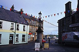
 Lerwick | |
| Location | |
 | |
| OS grid reference | HU414553 |
| Physical geography | |
| Island group | Shetland |
| Area | 96,879 hectares (374 sq mi)[1] |
| Area rank | 3 [2] |
| Highest elevation | Ronas Hill 450 metres (1,476 ft) |
| Administration | |
| Council area | Shetland Islands |
| Country | Scotland |
| Sovereign state | United Kingdom |
| Demographics | |
| Population | 18,765[3] |
| Population rank | 2 [2] |
| Population density | 19.41 people/km2[1] |
| Largest settlement | Lerwick |
| References | [4][5] |

The Mainland is the main island of Shetland, Scotland. The island contains Shetland's only burgh, Lerwick, and is the centre of Shetland's ferry and air connections.
It has an area of 374 square miles (970 km2), making it the third-largest Scottish island and the fifth largest of the British Isles after Great Britain, Ireland, Lewis and Harris and Skye.
The mainland can be broadly divided into four sections.
- The long southern peninsula, south of Lerwick, has a mixture of moorland and farmland and contains many important archaeological sites.
- The Central Mainland has more farmland and some woodland plantations.
- The West Mainland
- The North Mainland – in particular the large Northmavine peninsula, connected to Mainland by a narrow isthmus at Mavis Grind – is wild, with much moorland and coastal cliffs. The North Mainland contains Sullom Voe, whose oil terminal is an important source of employment for the islanders.
This island is the second most populous of the Scottish islands, and had 18,765 residents in 2011[3] compared to 17,550 in 2001.[7]
See also
References
- ^ a b Haswell-Smith (2004) p. 406
- ^ a b Area and population ranks: there are c. 300 islands over 20 ha in extent and 93 permanently inhabited islands were listed in the 2011 census.
- ^ a b National Records of Scotland (15 August 2013). "Appendix 2: Population and households on Scotland's Inhabited Islands" (PDF). Statistical Bulletin: 2011 Census: First Results on Population and Household Estimates for Scotland Release 1C (Part Two) (PDF) (Report). SG/2013/126. Retrieved 14 August 2020.
- ^ Haswell-Smith, Hamish (2004). The Scottish Islands. Edinburgh: Canongate. ISBN 978-1-84195-454-7.
- ^ Ordnance Survey
- ^ Shorewatch
- ^ General Register Office for Scotland (28 November 2003) Occasional Paper No 10: Statistics for Inhabited Islands Archived 2008-04-21 at the Wayback Machine. Retrieved 9 July 2007.
External links
Wikimedia Commons has media related to Shetland Mainland.

