District 5 (Tehran): Difference between revisions
Amirrezapl2r (talk | contribs) No edit summary |
Amirrezapl2r (talk | contribs) No edit summary |
||
| Line 19: | Line 19: | ||
}} |
}} |
||
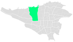
'''District 5''' ([[Persian]]:٫منطقه ۵also [[Romanization|romanized]] as '''Mantaqe ye Panj''' ) is one of 22 central districts of Tehran County in [[Tehran Province]], [[Iran]]. |
'''District 5''' ([[Persian]]:٫منطقه ۵also [[Romanization|romanized]] as '''Mantaqe ye Panj''' ) is one of 22 central districts of Tehran County in [[Tehran Province]], [[Iran]].This district is limited to Kan River and lands of District 22 in the west and to Mohammad Ali Jenah and Ashrafi Esfahani highways in the east. At the 2010 census, its population was 793,750, in 255,333 families.<ref>{{Cite web|url=https://region5.tehran.ir/|title=صفحه خانه|website=region5.tehran.ir|access-date=2019-12-01}}</ref> |
||
== Geography == |
|||
At the 2010 census, its population was 793,750, in 255,333 families.<ref>{{Cite web|url=https://region5.tehran.ir/|title=صفحه خانه|website=region5.tehran.ir|access-date=2019-12-01}}</ref> |
|||
District 5 of Tehran Municipality is located in northwest of the capital. The northern part of this municipal district is located on the height of the western slopes of [[Alborz]] Mountains and its southern part is in the neighborhood of Karaj Special Road.<ref>{{Cite web|url=http://en.tehran.ir/Default.aspx?tabid=130|title=::District 05|website=en.tehran.ir|access-date=2019-12-06}}</ref> |
|||
==== Neighborhoods ==== |
|||
| ⚫ | |||
The most famous neighborhoods of District 5 are [[Farahzad]], Kan and Sooleqan, Bagh-e Feyz, Poonak, [[Shahran, Tehran|Shahran]], [[Sadeghiyeh|Ariya-Shahr]] and [[Ekbatan]]. |
|||
| ⚫ | |||
== Areal details == |
== Areal details == |
||
The District 5 divided in seven regions and seventeen neighborhoods. |
The District 5 divided in seven regions and seventeen neighborhoods. |
||
Revision as of 19:11, 6 December 2019
District 5
Mantaqe ye Panj (منطقه پنج) | |
|---|---|
 | |
 | |
| Country | |
| Province | Tehran Province |
| Government | |
| • Mayor | Fereydoun Heidari |
| Area | |
• Total | 5,420 ha (13,390 acres) |
| Population | |
• Total | 856,565 |
District 5 (Persian:٫منطقه ۵also romanized as Mantaqe ye Panj ) is one of 22 central districts of Tehran County in Tehran Province, Iran.This district is limited to Kan River and lands of District 22 in the west and to Mohammad Ali Jenah and Ashrafi Esfahani highways in the east. At the 2010 census, its population was 793,750, in 255,333 families.[1]
Geography
District 5 of Tehran Municipality is located in northwest of the capital. The northern part of this municipal district is located on the height of the western slopes of Alborz Mountains and its southern part is in the neighborhood of Karaj Special Road.[2]
Neighborhoods
The most famous neighborhoods of District 5 are Farahzad, Kan and Sooleqan, Bagh-e Feyz, Poonak, Shahran, Ariya-Shahr and Ekbatan.
Areal details
The District 5 divided in seven regions and seventeen neighborhoods.
| Area | Population | km² | Seat (Location) | Mayor | Ref |
|---|---|---|---|---|---|
| 1 | 77,203 | 6.2 | Shahr-e ziba | (Persian:علیرضا فاطمی نیک) | [1] |
| 2 | 55,549 | 6.8 | Shahr-e ziba | (Persian:محمد اسدالهی) | [2] |
| 3 | - | 35.1 | Ashrafi Esfahani Expressway | (Persian:علیرضا غفارخانی) | [3] |
| 4 | - | 35.1 | Ayatollah Kashani Expressway | (Persian:مریم تراشی) | [4] |
| 5 | - | 1.485 | Ayatollah Kashani Expressway | (Persian:رضا علیزمانی) | [5] |
| 6 | - | - | Ekbatan Town | (Persian:سمانه عبدالهی) | [6] |
| 7 | 186,988 | 8 | Shahid Sattari Expressway | (Persian:امیر نجف نژاد) | [7] |
Reference
- ^ "صفحه خانه". region5.tehran.ir. Retrieved 2019-12-01.
- ^ "::District 05". en.tehran.ir. Retrieved 2019-12-06.
| This Iran location article is a stub. You can help Wikipedia by expanding it. |
