Wuda District: Difference between revisions
Appearance
Content deleted Content added
No edit summary |
m →References: Task 15: language icon template(s) replaced (1×); |
||
| Line 113: | Line 113: | ||
==References== |
==References== |
||
*[http://www.xzqh.org/html/index.html www.xzqh.org] {{ |
*[http://www.xzqh.org/html/index.html www.xzqh.org] {{in lang|zh}} |
||
{{County-level divisions of Inner Mongolia}} |
{{County-level divisions of Inner Mongolia}} |
||
Revision as of 05:31, 4 January 2020
Ud
乌达区 • ᠤᠳᠠᠲᠣᠭᠣᠷᠢᠭ | |
|---|---|
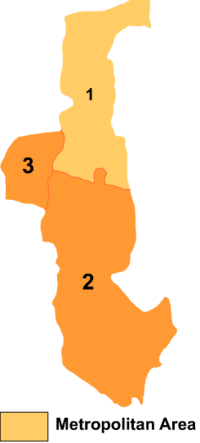
 Wuda is the division labeled '3' on this map of Wuhai City | |
| Coordinates: 39°30′21″N 106°43′03″E / 39.50583°N 106.71750°E | |
| Country | People's Republic of China |
| Prefecture-level city | Wuhai |
| Time zone | UTC+8 (China Standard) |
Ud District or Wuda District (Mongolian: ᠤᠳᠠ ᠲᠣᠭᠣᠷᠢᠭ Уда тоори Uda toɣoriɣ; simplified Chinese: 乌达区; traditional Chinese: 烏達區; pinyin: Wūdá Qū) is a district of the city of Wuhai, Inner Mongolia, People's Republic of China, located on the west (left) bank of the Yellow River.
References
- www.xzqh.org (in Chinese)
