St Leonards Warrior Square railway station: Difference between revisions
CoolSkittle (talk | contribs) Add caption Tags: Mobile edit Mobile web edit |
Randomman44 (talk | contribs) Added 2018/19 station usage figures |
||
| Line 20: | Line 20: | ||
| usage1011 = {{increase}} 0.679 |
| usage1011 = {{increase}} 0.679 |
||
| usage1112 = {{decrease}} 0.666 |
| usage1112 = {{decrease}} 0.666 |
||
| usage1213 = {{decrease}} 0.655 |
| usage1213 = {{decrease}} 0.655 |
||
| usage1314 = {{increase}} 0.677 |
| usage1314 = {{increase}} 0.677 --> |
||
| usage1415 = {{increase}} 0.734 |
| usage1415 = {{increase}} 0.734 |
||
| usage1516 = {{increase}} 0.759 |
| usage1516 = {{increase}} 0.759 |
||
| usage1617 = {{decrease}} 0.651 |
| usage1617 = {{decrease}} 0.651 |
||
| usage1718 = {{increase}} 0.741 |
| usage1718 = {{increase}} 0.741 |
||
| usage1819 = {{increase}} 0.820 |
|||
| years1 = {{start date|1851|02|13|df=y}} |
| years1 = {{start date|1851|02|13|df=y}} |
||
| events1 = Opened as ''St Leonards''<ref name="Butt">Butt, R.V.J. (1995). ''The Directory of Railway Stations'', Patrick Stephens Ltd, Sparkford, {{ISBN|1-85260-508-1}}, p. 204.</ref> |
| events1 = Opened as ''St Leonards''<ref name="Butt">Butt, R.V.J. (1995). ''The Directory of Railway Stations'', Patrick Stephens Ltd, Sparkford, {{ISBN|1-85260-508-1}}, p. 204.</ref> |
||
Revision as of 19:40, 14 January 2020
St Leonards Warrior Square | |
|---|---|
| General information | |
| Location | Hastings, East Sussex |
| Managed by | Southeastern |
| Platforms | 2 |
| Other information | |
| Station code | SLQ |
| Key dates | |
| 13 February 1851 | Opened as St Leonards[1] |
| 5 December 1870 | Renamed St Leonards Warrior Square[1] |
| 1 January 1917 | Closed[1] |
| 1 January 1919 | Reopened[1] |
St Leonards Warrior Square railway station is on the Hastings line in the south of England and is one of four stations that serve Hastings, East Sussex. It is 61 miles 55 chains (99.3 km) down the line from London Charing Cross and is situated between West St Leonards and Hastings. The station is operated by Southeastern.
History
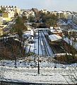
The station building and house, still in existence today, were constructed in 1851 by the South Eastern Railway (SER). The competing London, Brighton and South Coast Railway (LBSCR) trains were not allowed to stop here until December 1870.[2] The two companies maintained separate booking offices until 1923 when they both became part of the Southern Railway. The station is constructed in a narrow valley with higher ground east and west, so that trains arrive and depart either end of the platform through tunnels. This restricts the number of carriages which have direct access to the platform to 8 cars.
Services
Railway stations in Hastings | |||||||||||||||||||||||||||||||||||||||||||||||||||||||||||||||||||||||||||||||||||||||||||||||||||||||||||||||
|---|---|---|---|---|---|---|---|---|---|---|---|---|---|---|---|---|---|---|---|---|---|---|---|---|---|---|---|---|---|---|---|---|---|---|---|---|---|---|---|---|---|---|---|---|---|---|---|---|---|---|---|---|---|---|---|---|---|---|---|---|---|---|---|---|---|---|---|---|---|---|---|---|---|---|---|---|---|---|---|---|---|---|---|---|---|---|---|---|---|---|---|---|---|---|---|---|---|---|---|---|---|---|---|---|---|---|---|---|---|---|---|
| |||||||||||||||||||||||||||||||||||||||||||||||||||||||||||||||||||||||||||||||||||||||||||||||||||||||||||||||
Services at the station are operated by either Southeastern Trains via the Hastings Line or by Southern Trains via the East Coastway Line and the Marshlink Line. Southeastern services use Class 375 electric multiple units. Southern services use Class 377 electric multiple units and Class 171 diesel multiple units.
As of May 2018 the typical off-peak service from the station is:
- Southern
- 1tph to London Victoria via the East Coastway Line (semi-fast)
- 2tph to Brighton via the East Coastway Line (both semi-fast)
- 1tph to Eastbourne (stopping)
- 1tph to Ashford International via Hastings and the Marshlink Line (semi-fast)
- 2tph to Ore via Hastings
- Southeastern
- 2tph to London Charing Cross via the Hastings Line (1 semi-fast, 1 stopping)
- 2tph to Hastings (direct)[3]
There are also peak hour services to London Cannon Street operated by Southeastern.
Gallery
-
The platform
-
Above the tunnel mouth
-
Above the tunnel mouth, in the snow (January 2006)
-
A 1914 Railway Clearing House map of lines around St Leonards Warrior Square railway station.
References
- ^ a b c d Butt, R.V.J. (1995). The Directory of Railway Stations, Patrick Stephens Ltd, Sparkford, ISBN 1-85260-508-1, p. 204.
- ^ White, H.P. (1992). A Regional History of the Railways of Great Britain: Southern England (Vol. 2). Nairn, Scotland: David St John Thomas. p. 35. ISBN 0-946537-77-1.
{{cite book}}: Cite has empty unknown parameter:|coauthors=(help) - ^ Network Rail Timetable May 2010: Table 206
External links
- Train times and station information for St Leonards Warrior Square railway station from National Rail


