Bystraya River: Difference between revisions
→Sources: another |
→Course: detail |
||
| Line 79: | Line 79: | ||
It is joined from the left by the [[Plotnikova River]] at {{convert|55|km}} from the river mouth to form the Bolshaya.{{sfn|Fishing on Bolshaya river}} |
It is joined from the left by the [[Plotnikova River]] at {{convert|55|km}} from the river mouth to form the Bolshaya.{{sfn|Fishing on Bolshaya river}} |
||
The Bystraya / Bolshaya River is {{convert|275|km}} long and has a catchment area of {{convert|10,800|km2}}.{{sfn|Река Большая, Быстрая}} |
The Bystraya / Bolshaya River is {{convert|275|km}} long and has a catchment area of {{convert|10,800|km2}}.{{sfn|Река Большая, Быстрая}} |
||
==Settlements== |
|||
The village of [[Malka, Kamchatka Krai|Malka]] is on left bank of the upper part of the river. |
|||
The first use of the name Malka is by the French traveler [[Barthélemy de Lesseps]] in 1787. |
|||
He said it had five or six huts and 15 sheds, on the bank of the Bystraya River, surrounded by high mountains, with a hot spring nearby.{{sfn|Borisov|2008}} |
|||
The village of [[Bolsheretsk]] was located near the point where the Reka Bolshaya and Reka Bystraya converge, about {{convert|10|mi}} upstream of [[Ust-Bolsheretsk]].{{sfn|United States Hydrographic Office|1932|p=180}} |
The village of [[Bolsheretsk]] was located near the point where the Reka Bolshaya and Reka Bystraya converge, about {{convert|10|mi}} upstream of [[Ust-Bolsheretsk]].{{sfn|United States Hydrographic Office|1932|p=180}} |
||
Revision as of 20:09, 11 February 2020
| Bystraya River | |
|---|---|
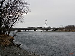
 A bridge over the Bystraya river near the village of Kavalerskoye | |
| Native name | реку Быстрая Error {{native name checker}}: parameter value is malformed (help) |
| Location | |
| Country | Russia |
| Federal subject | Kamchatka Krai |
| District | Yelizovsky District, Ust-Bolsheretsky District |
| Physical characteristics | |
| Mouth | |
• location | Bolshaya River |
• coordinates | 52°55′04″N 156°34′46″E / 52.917778°N 156.579322°E |
| Basin features | |
| River system | Bolshaya River |
The Bystraya River (Template:Lang-ru, or Rapid River) is a river in the western Kamchatka Peninsula, Russia, a tributary of the Bolshaya River. It is used for spawning by various species of Pacific salmon.
Course
The Bystraya River forms on the southern part of the Sredinny Ridge.[1] In its middle reaches the river is 20–40 metres (66–131 ft) wide and 0.8–2 metres (2 ft 7 in – 6 ft 7 in) deep. Lower down it is 50–100 metres (160–330 ft) wide and 1–3 metres (3 ft 3 in – 9 ft 10 in) deep.[1] Water levels are highest in June due to snow melt in the mountains.[2]
The Bystraya River forms the upper part of the Bolshaya River.[3] It is joined from the left by the Plotnikova River at 55 kilometres (34 mi) from the river mouth to form the Bolshaya.[3] The Bystraya / Bolshaya River is 275 kilometres (171 mi) long and has a catchment area of 10,800 square kilometres (4,200 sq mi).[4]
Settlements
The village of Malka is on left bank of the upper part of the river. The first use of the name Malka is by the French traveler Barthélemy de Lesseps in 1787. He said it had five or six huts and 15 sheds, on the bank of the Bystraya River, surrounded by high mountains, with a hot spring nearby.[5]
The village of Bolsheretsk was located near the point where the Reka Bolshaya and Reka Bystraya converge, about 10 miles (16 km) upstream of Ust-Bolsheretsk.[6] In the late 1920s the people of that village on the islands decided to relocate to a more convenient location on the Kavalerskaya channel six miles down the river. In the spring of 1928, there were already three houses on the Kavalerskaya channel, two more were under construction.[7] The new village was formed by 1930. Until 1990, it was called the Bolsheretsky state farm (Template:Lang-ru) after its location on the right bank of the Bolshaya River. In 1990 it was renamed Kavalerskoye.[8]
Fish
The tributaries of the Bystraya River are important spawning grounds for chinook salmon, sockeye salmon, pink salmon, chum salmon and coho salmon. It is also used by migrating arctic char, grayling, rainbow trout and whitespotted char.[1] During the salmon spawning season there are often brown bears in the river.[2]
References
Sources
- Borisov, Viktor (2008), "Мalka (part 1)", Gazeta Vesti (in Russian), retrieved 2020-02-10
{{citation}}: Invalid|ref=harv(help) - Bystraya River - rafting, volcanoesland, retrieved 2020-02-09
- "Fishing on Bolshaya river", kamchatka-fishing.ru, retrieved 2020-02-02
- Населенные пункты Камчатки (даты возникновения, наименования, переименования, упразднения; краткая топонимика Камчатки)
- "Река Большая, Быстрая", государственного водного реестра (in Russian), retrieved 2020-02-02
- Смышляев, Александр (2011), Камчатский край. Большерецкие веси, Петропавловск-Камчатский: Новая книга, pp. 38–40
{{citation}}: Invalid|ref=harv(help) - "The Bystraya River", Orca Diving, retrieved 2020-02-09
- United States Hydrographic Office (1932), Sailing Directions for Siberia and Chosen, from Cape Syeverni and Wrangell Island to the Orycku Ko (Yalu River) Including Sakhalin Island, U.S. Government Printing Office, retrieved 2020-02-02

