Kuttippuram: Difference between revisions
Appearance
Content deleted Content added
m Reverted edits by 49.15.208.50 (talk) (HG) (3.4.9) |
Rescuing 1 sources and tagging 0 as dead.) #IABot (v2.0 |
||
| Line 72: | Line 72: | ||
==External links== |
==External links== |
||
{{commons category}} |
{{commons category}} |
||
* [http://www.kuttippuram.com Kuttippuram website] |
* [https://web.archive.org/web/20091120073308/http://www.kuttippuram.com/ Kuttippuram website] |
||
*[http://www.kudallur.com Kudallur Village] |
*[http://www.kudallur.com Kudallur Village] |
||
Revision as of 18:21, 20 February 2020
Kuttippuram | |
|---|---|
Town | |
 Kuttippuram | |
 | |
| Coordinates: 10°50′38″N 76°01′58″E / 10.84389°N 76.03278°E | |
| Country | |
| State | Kerala |
| District | Malappuram |
| Languages | |
| • Official | Malayalam, English |
| Time zone | UTC+5:30 (IST) |
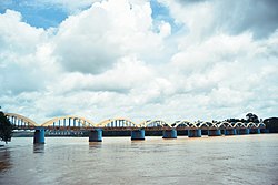
Kuttippuram is a town and is situated in the Malappuram district of Kerala state, India. The town is located 34 kilometres south-west of Malappuram. The Bharathappuzha river flows through Kuttippuram.
Geography
Kuttippuram is located at 10°50′N 76°04′E / 10.83°N 76.07°E.[1] It has an average elevation of 15 m (49 ft).
Educational Institutions
School(s)
- ALP School, Kuttippuram South
- Govt. Higher Secondary School, Kuttippuram
- Govt. High UP & High School
- Govt. Vocational Higher Secondary School, Kuttippuram
- Sree Durga Vidhiya Nikethan English Medium U.P School
- Technical High School, Kuttippuram
College(s)
- MAS College, Kuttippuram
- MES College of Engineering
References
External links
Wikimedia Commons has media related to Kuttippuram.
