Wuda District: Difference between revisions
Appearance
Content deleted Content added
m →References: add authority control |
m clean up |
||
| Line 1: | Line 1: | ||
{{Infobox settlement |
{{Infobox settlement |
||
<!--See Template:Infobox Settlement for additional fields that may be available--> |
<!--See Template:Infobox Settlement for additional fields that may be available--> |
||
<!--See the Table at Infobox Settlement for all fields and descriptions of usage--> |
|||
<!-- Basic info ----------------> |
<!-- Basic info ----------------> |
||
|name =Ud |
|name =Ud |
||
|other_name = |
|other_name = |
||
|native_name ={{lower|0.1em |
|native_name ={{lower|0.1em|{{lang|zh-hans|乌达区}} • {{MongolUnicode|ᠤᠳᠠ}}{{MongolUnicode|ᠲᠣᠭᠣᠷᠢᠭ}}}} |
||
|settlement_type =[[District (PRC)|District]] |
|settlement_type =[[District (PRC)|District]] |
||
|total_type = <!-- to set a non-standard label for total area and population rows --> |
|total_type = <!-- to set a non-standard label for total area and population rows --> |
||
| Line 13: | Line 12: | ||
|imagesize = |
|imagesize = |
||
|image_caption = |
|image_caption = |
||
|image_flag = |
|||
|flag_size = |
|||
|image_seal = |
|image_seal = |
||
|seal_size = |
|seal_size = |
||
| Line 32: | Line 29: | ||
|dot_map_caption = |
|dot_map_caption = |
||
|dot_x = |dot_y = |
|dot_x = |dot_y = |
||
| pushpin_map = |
|||
|pushpin_map = <!-- the name of a location map as per http://en.wikipedia.org/wiki/Template:Location_map --> |
|||
|pushpin_label_position = <!-- the position of the pushpin label: left, right, top, bottom, none --> |
|pushpin_label_position = <!-- the position of the pushpin label: left, right, top, bottom, none --> |
||
|pushpin_map_caption = |
|pushpin_map_caption = |
||
| Line 102: | Line 99: | ||
|timezone = [[China Standard Time|China Standard]] |
|timezone = [[China Standard Time|China Standard]] |
||
|utc_offset = +8 |
|utc_offset = +8 |
||
|coor_pinpoint = Ud District government |
|||
|coordinates = {{coord|39 |
|coordinates = {{coord|39.5056|N|106.7260|E|type:adm2nd_region:CN-15_source:Gaode|format=dms|display=it}} |
||
<!-- Area/postal codes & others --------> |
<!-- Area/postal codes & others --------> |
||
|postal_code_type = [[Postal code of China|Postal code]] |
|postal_code_type = [[Postal code of China|Postal code]] |
||
| Line 116: | Line 114: | ||
{{County-level divisions of Inner Mongolia}} |
{{County-level divisions of Inner Mongolia}} |
||
{{authority control}} |
{{authority control}} |
||
Revision as of 19:00, 30 April 2020
Ud
乌达区 • ᠤᠳᠠᠲᠣᠭᠣᠷᠢᠭ | |
|---|---|
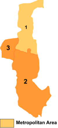
 Wuda is the division labeled '3' on this map of Wuhai City | |
| Coordinates (Ud District government): 39°30′20″N 106°43′34″E / 39.5056°N 106.7260°E | |
| Country | People's Republic of China |
| Prefecture-level city | Wuhai |
| Time zone | UTC+8 (China Standard) |
Ud District or Wuda District (Mongolian: ᠤᠳᠠ ᠲᠣᠭᠣᠷᠢᠭ Уда тоори Uda toɣoriɣ; simplified Chinese: 乌达区; traditional Chinese: 烏達區; pinyin: Wūdá Qū) is a district of the city of Wuhai, Inner Mongolia, People's Republic of China, located on the west (left) bank of the Yellow River.
References
- www.xzqh.org (in Chinese)
