Downtown Vancouver: Difference between revisions
Revert to revision 89608382 dated 2006-11-23 06:47:53 by Denelson83 using popups |
No edit summary |
||
| Line 3: | Line 3: | ||
==Geography== |
==Geography== |
||
[[Image:Downtown_Vancouver_Stanley_Park.JPG|thumb|left|Downtown Vancouver with the West End and Stanley Park]] |
[[Image:Downtown_Vancouver_Stanley_Park.JPG|thumb|350px|left|Downtown Vancouver with the West End and Stanley Park]] |
||
The downtown area is generally considered to be bounded by [[Burrard Inlet]] to the north, [[Stanley Park]] and the [[West End, Vancouver|West End]] to the west, [[False Creek]] to the south, and the [[Downtown Eastside]] to the east. Some sources include the West End and Stanley Park as part of downtown, but the City of Vancouver defines them as separate neighbourhoods. |
The downtown area is generally considered to be bounded by [[Burrard Inlet]] to the north, [[Stanley Park]] and the [[West End, Vancouver|West End]] to the west, [[False Creek]] to the south, and the [[Downtown Eastside]] to the east. Some sources include the West End and Stanley Park as part of downtown, but the City of Vancouver defines them as separate neighbourhoods. |
||
Revision as of 20:02, 21 December 2006

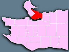
Downtown Vancouver is the term used to describe the southeastern portion of the peninsula in the north-central part of Vancouver proper. It is the business, commercial, cultural, and entertainment centre of the city and also of the Greater Vancouver Regional District.
Geography

The downtown area is generally considered to be bounded by Burrard Inlet to the north, Stanley Park and the West End to the west, False Creek to the south, and the Downtown Eastside to the east. Some sources include the West End and Stanley Park as part of downtown, but the City of Vancouver defines them as separate neighbourhoods.
Besides the readily identifiable office towers of the Financial and Central Business Districts, downtown Vancouver also includes Yaletown, a former industrial area that has been transformed into an upscale residential neighbourhood; and Coal Harbour. Other downtown neighbourhoods include the Granville Entertainment District, Downtown South, Gastown, Japantown, Koreatown, and Chinatown.
Transportation
The presence of water on three sides limits access to downtown Vancouver. There are four major bridges: the Lions Gate Bridge, connecting to the North Shore municipalities and the Trans Canada Highway, and the Burrard, Cambie, and Granville bridges providing access to the commercial and residential areas south of False Creek.
The historic Waterfront Station is a major intermodal transit hub for the downtown core. Most north-south Vancouver bus routes serve the area, in addition to suburban routes from the North Shore, Burnaby, the Tri-Cities, Richmond, Delta, and South Surrey. There are four subway SkyTrain stations, using the shared Expo and Millennium Line tracks from Waterfront Station through the old Dunsmuir Tunnel. The SeaBus ferry provides passenger service to the North Shore, the West Coast Express commuter rail system travels to the eastern suburbs, and there are terminals for float plane and helicopter services along Burrard Inlet.
The bus rapid transit line 98 B-Line has eight stops in the downtown core, primarily along Seymour Street and Burrard Street. This service will be replaced in 2009 by the Canada Line, currently under construction, which will link downtown to Richmond and Vancouver International Airport. There will be three subway stations downtown on this line, originating at Waterfront Station.
Sports
There are two major sports facilities in the downtown core. The NHL's Vancouver Canucks play at GM Place, while the CFL's BC Lions use the neighbouring BC Place Stadium. A proposal for Whitecaps Waterfront Stadium, a soccer stadium east of Waterfront Station to house the USL's Vancouver Whitecaps, is currently under consideration.
External links
