Uckerfelde: Difference between revisions
Appearance
Content deleted Content added
→Demography: Latest data added |
mNo edit summary |
||
| Line 21: | Line 21: | ||
|mayor = Manfred Endrunat |
|mayor = Manfred Endrunat |
||
}} |
}} |
||
'''Uckerfelde''' is a [[Municipalities of Germany|municipality]] in the [[Uckermark]] district |
'''Uckerfelde''' is a [[Municipalities of Germany|municipality]] in the [[Uckermark]] district of [[Brandenburg]], [[Germany]]. |
||
==Demography== |
==Demography== |
||
Revision as of 11:35, 31 May 2020
Uckerfelde | |
|---|---|
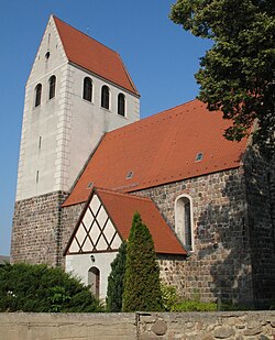
 Church in Bietikow | |
Location of Uckerfelde within Uckermark district  | |
| Coordinates: 53°15′54″N 13°57′00″E / 53.265°N 13.95°E | |
| Country | Germany |
| State | Brandenburg |
| District | Uckermark |
| Municipal assoc. | Gramzow |
| Government | |
| • Mayor | Manfred Endrunat |
| Area | |
• Total | 45.93 km2 (17.73 sq mi) |
| Elevation | 78 m (256 ft) |
| Population (2022-12-31)[1] | |
• Total | 954 |
| • Density | 21/km2 (54/sq mi) |
| Time zone | UTC+01:00 (CET) |
| • Summer (DST) | UTC+02:00 (CEST) |
| Postal codes | 17291 |
| Dialling codes | 039858, 039861 |
| Vehicle registration | UM |
| Website | www.amtgramzow.de |
Uckerfelde is a municipality in the Uckermark district of Brandenburg, Germany.
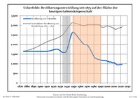
Demography

|
|
|
References
- ^ "Bevölkerungsentwicklung und Bevölkerungsstandim Land Brandenburg Dezember 2022" (PDF). Amt für Statistik Berlin-Brandenburg (in German). June 2023.
- ^ Detailed data sources are to be found in the Wikimedia Commons.Population Projection Brandenburg at Wikimedia Commons


