Cheruvathur: Difference between revisions
Appearance
Content deleted Content added
m Dating maintenance tags: {{Unreferenced}} |
→Transportation: Newly opened nearest airport added. Tags: Mobile edit Mobile web edit |
||
| Line 52: | Line 52: | ||
==Transportation== |
==Transportation== |
||
Local roads have access to NH.66 which connects to [[Mangalore]] in the north and [[ |
Local roads have access to NH.66 which connects to [[Mangalore]] in the north and [[Kannur]] in the south. The nearest railway station is [[Cheruvathur railway station|Cheruvathur]] on Mangalore-[[Palakkad]] line. There are airports at [[Mangalore Airport|Mangalore]] and [[Kannur International Airport|Kannur]]. |
||
==See also== |
==See also== |
||
Revision as of 16:12, 3 June 2020
Cheruvathur | |
|---|---|
Town | |
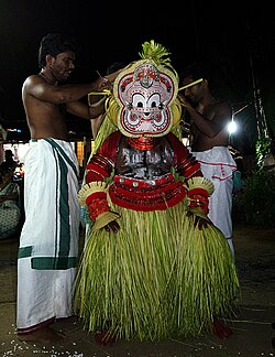
 Pottam Theyyam at Cheruvathur | |
| Coordinates: 12°19′00″N 75°04′59″E / 12.3167°N 75.083°E | |
| Country | |
| State | Kerala |
| District | Kasaragod |
| Area | |
• Total | 18.37 km2 (7.09 sq mi) |
| Languages | |
| • Official | Malayalam, English |
| Time zone | UTC+5:30 (IST) |
| PIN | 671313 |
Cheruvathur is a town in the Kasaragod district, state of Kerala. It is located 58 km from the district headquarters at Kasaragod Town.
Transportation
Local roads have access to NH.66 which connects to Mangalore in the north and Kannur in the south. The nearest railway station is Cheruvathur on Mangalore-Palakkad line. There are airports at Mangalore and Kannur.
See also
References
External links
Wikimedia Commons has media related to Cheruvathur.


