Postcode district boundaries :
From Wikipedia, the free encyclopedia
Content deleted Content added
Line 124:
Line 124:
! SY21
! SY21
| WELSHPOOL
| WELSHPOOL
| [[Welshpool]], [[Marton, Shropshire|Marton]], [[Stockton, Shropshire|Stockton]]
| [[Welshpool]], [[Marton, Shropshire|Marton]], [[Stockton, Chirbury with Brompton |Stockton]]
| Powys, Shropshire
| Powys, Shropshire
|-
|-
Revision as of 21:13, 17 June 2020
Postcode area within the United Kingdom
KML is from Wikidata
Postcode area in United Kingdom
The SY postcode area , also known as the Shrewsbury postcode area ,[ 2] Shropshire (including Shrewsbury , Oswestry , Ludlow , Bucknell , Whitchurch , Bishop's Castle , Craven Arms , Church Stretton , Ellesmere , Lydbury North and Llanymynech ), north Powys (including Montgomery , Newtown , Welshpool , Caersws , Llanbrynmair , Llanfechain , Llanfyllin , Llandinam , Llanidloes , Llansantffraid , Machynlleth and Meifod ), and north Ceredigion (including Aberystwyth , Borth , Bow Street , Tregaron , Talybont , Ystrad Meurig , Llanrhystud and Llanon ), plus small parts of south Cheshire (including Malpas ) and north Herefordshire , and very small parts of Gwynedd and Wrexham County Borough .
Coverage
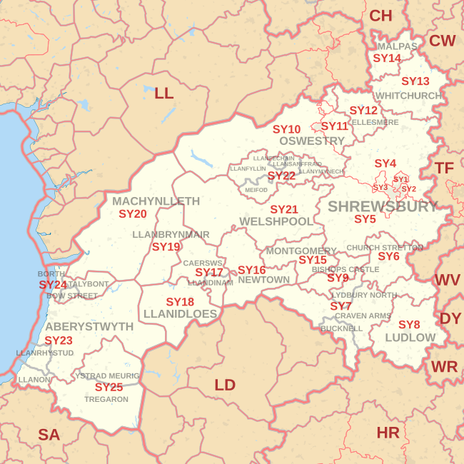
The approximate coverage of the postcode districts:
Postcode district
Post town
Coverage
Local authority area(s)
SY1
SHREWSBURY
Shrewsbury (north and town centre)
Shropshire
SY2
SHREWSBURY
Shrewsbury (east)
Shropshire
SY3
SHREWSBURY
Shrewsbury (south and west), Bayston Hill
Shropshire
SY4
SHREWSBURY
Baschurch , Bomere Heath , Nesscliffe , Shawbury , Wem
Shropshire
SY5
SHREWSBURY
Atcham , Cressage , Criggion , Condover , Minsterley , Pontesbury , Ratlinghope , Westbury , Wroxeter
Shropshire, Powys
SY6
CHURCH STRETTON
Church Stretton , Cardington
Shropshire
SY7
BUCKNELL
Bucknell , Lingen , Munslow , Tugford
Shropshire, Herefordshire
CRAVEN ARMS
Craven Arms , Clun Valley , Diddlebury , Leintwardine , Munslow , Tugford
LYDBURY NORTH
Lydbury North
Shropshire
SY8
LUDLOW
Ludlow , Brimfield , Clee Hill , Culmington , Leinthall Starkes , Richard's Castle , Stoke St. Milborough
Shropshire, Herefordshire
SY9
BISHOPS CASTLE
Bishop's Castle , Wentnor
Shropshire
SY10
OSWESTRY
Oswestry (outskirts), Gobowen , Llansilin , Llangedwyn , Llanrhaeadr-ym-Mochnant , Pen-y-bont-fawr, Llanwddyn
Shropshire, Powys
SY11
OSWESTRY
Oswestry (most of), St Martin's , West Felton
Shropshire
SY12
ELLESMERE
Ellesmere , Dudleston Heath (Criftins) , Welshampton , Lyneal, Colemere, Cockshutt , English Frankton , Tetchill, Hordley , Bagley
Shropshire
SY13
WHITCHURCH
Whitchurch , Whixall
Shropshire
SY14
MALPAS
Malpas , Tilston , No Man's Heath , Bickley , Hampton , Shocklach , Bulkeley , Bickerton , Cuddington Heath , Cholmondeley , Threapwood , Barton , Duckington
Cheshire West and Chester , Cheshire East , Wrexham
SY15
MONTGOMERY
Montgomery , Abermule , Chirbury , Church Stoke
Powys, Shropshire
SY16
NEWTOWN
Newtown , Tregynon , Bettws Cedewain
Powys
SY17
CAERSWS
Caersws , Trefeglwys , Carno , Llanwnnog , Pontdolgoch , Clatter
Powys
LLANDINAM
Llandinam
SY18
LLANIDLOES
Llanidloes , Llangurig , Van , Tylwch
Powys
SY19
LLANBRYNMAIR
Llanbrynmair , Llan , Bont Dolgadfan , Dolfach , Talerddig , Staylittle , Pennant , Dylife
Powys
SY20
MACHYNLLETH
Machynlleth , Corris
Powys, Gwynedd
SY21
WELSHPOOL
Welshpool , Marton , Stockton
Powys, Shropshire
SY22
LLANFECHAIN
Llanfechain
Powys
LLANFYLLIN
Llanfyllin
LLANSANTFFRAID
Llansantffraid-ym-Mechain
LLANYMYNECH
Llanymynech
MEIFOD
Meifod
SY23
ABERYSTWYTH
Aberystwyth , Llanbadarn Fawr , Penparcau
Ceredigion
LLANON
Llanon
LLANRHYSTUD
Llanrhystud
SY24
BORTH
Borth
Ceredigion
BOW STREET
Bow Street , Pen-y-garn , Rhydypennau , Llandre
TALYBONT
Talybont
SY25
YSTRAD MEURIG
Ystrad Meurig
Ceredigion
TREGARON
Tregaron
SY99
SHREWSBURY
Jobcentre Plus non-geographic
Map
KML is from Wikidata
SY postcode area map, showing postcode districts in red and post towns in grey text, with links to nearby CH , CW , DY , HR , LD , LL , SA , TF , WR and WV postcode areas.
See also
References
External links
Crown dependencies Overseas territories Non-geographic


