Zhaojue County: Difference between revisions
2020 relocation |
add eponymous Category:Zhaojue County; apply WP:GENFIXES |
||
| Line 136: | Line 136: | ||
{{Authority control}} |
{{Authority control}} |
||
[[Category:Zhaojue County| ]] |
|||
[[Category:Liangshan Yi Autonomous Prefecture]] |
[[Category:Liangshan Yi Autonomous Prefecture]] |
||
[[Category:Amdo]] |
[[Category:Amdo]] |
||
[[Category:County-level divisions of Sichuan]] |
[[Category:County-level divisions of Sichuan]] |
||
{{Sichuan-geo-stub}} |
{{Sichuan-geo-stub}} |
||
Revision as of 17:11, 20 June 2020
Zhaojue County
昭觉县 · ꏪꐦꑤ | |
|---|---|
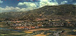
 Zhaojue County in 1964 | |
 Location of Zhaojue County (red) within Liangshan Prefecture (yellow) and Sichuan | |
| Coordinates: 28°00′50″N 102°50′35″E / 28.014°N 102.843°E | |
| Country | People's Republic of China |
| Province | Sichuan |
| Autonomous prefecture | Liangshan |
| Area | |
• Total | 2,699 km2 (1,042 sq mi) |
| Time zone | UTC+8 (China Standard) |
Zhaojue County is a county in the south of Sichuan Province, China. It is under the administration of the Liangshan Yi Autonomous Prefecture.
Atulie'er Village
The remote Atulie'er Village[1] (Atulie'ercun, 阿土列尔村) [note: also transliterated as Atuleer, and Ado Ler] , is located in the Zhi'ermo Township (支尔莫乡)[2] of Zhaojue County. The village was the focus of a Chinese news video and photojournalism that became international news in May, 2016.[3] Due to the 200 year-old village's isolated location, perched like the seat of a chair with near-vertical cliffs both above and below, village children must use a series of handmade ladders to scale the 2,625 feet (800 m) cliff to reach a school in the river valley below. Parents supervise their children during the crossing due to the potential hazards. The school, which serves ages 6–15, had 15 students as of 2016.[4][deprecated source] Students travel between their school and their residences every two weeks, and for the school period reside in dormitories on campus due to the ladder situation.[5]
In 2015 Chen Jie of The Beijing News photographed the children on the ladder. The pictures went viral on the internet, prompting local authorities to announce that they will construct a staircase to serve the students.[6] In 2020, the Chinese government began relocating the majority of Atulie'er's residents to the county seat of Zhaojue and converting the remaining village to a tourist site.[7]
Villages such as Atuli'er are often dubbed Cliff villages due to their height and remoteness.
Climate
| Climate data for Zhaojue (1981−2010) | |||||||||||||
|---|---|---|---|---|---|---|---|---|---|---|---|---|---|
| Month | Jan | Feb | Mar | Apr | May | Jun | Jul | Aug | Sep | Oct | Nov | Dec | Year |
| Record high °C (°F) | 23.9 (75.0) |
25.6 (78.1) |
30.8 (87.4) |
31.0 (87.8) |
33.0 (91.4) |
33.1 (91.6) |
31.3 (88.3) |
31.9 (89.4) |
31.6 (88.9) |
28.4 (83.1) |
24.6 (76.3) |
21.5 (70.7) |
33.1 (91.6) |
| Mean daily maximum °C (°F) | 8.8 (47.8) |
11.6 (52.9) |
16.2 (61.2) |
19.8 (67.6) |
21.6 (70.9) |
22.3 (72.1) |
24.4 (75.9) |
24.5 (76.1) |
21.0 (69.8) |
16.4 (61.5) |
13.7 (56.7) |
10.0 (50.0) |
17.5 (63.5) |
| Daily mean °C (°F) | 1.6 (34.9) |
4.0 (39.2) |
8.0 (46.4) |
12.1 (53.8) |
15.1 (59.2) |
17.1 (62.8) |
19.0 (66.2) |
18.6 (65.5) |
15.4 (59.7) |
11.3 (52.3) |
7.4 (45.3) |
3.1 (37.6) |
11.1 (51.9) |
| Mean daily minimum °C (°F) | −2.2 (28.0) |
−0.4 (31.3) |
2.8 (37.0) |
6.9 (44.4) |
10.7 (51.3) |
13.7 (56.7) |
15.4 (59.7) |
14.8 (58.6) |
12.1 (53.8) |
8.4 (47.1) |
3.9 (39.0) |
−0.7 (30.7) |
7.1 (44.8) |
| Record low °C (°F) | −11.3 (11.7) |
−10.2 (13.6) |
−7.4 (18.7) |
−2.3 (27.9) |
−0.1 (31.8) |
7.8 (46.0) |
8.6 (47.5) |
7.4 (45.3) |
3.2 (37.8) |
−0.4 (31.3) |
−5.6 (21.9) |
−17.0 (1.4) |
−17.0 (1.4) |
| Average precipitation mm (inches) | 9.4 (0.37) |
12.9 (0.51) |
26.5 (1.04) |
55.0 (2.17) |
117.1 (4.61) |
203.6 (8.02) |
205.1 (8.07) |
158.4 (6.24) |
135.0 (5.31) |
76.0 (2.99) |
25.2 (0.99) |
8.8 (0.35) |
1,033 (40.67) |
| Average relative humidity (%) | 75 | 69 | 66 | 69 | 74 | 81 | 81 | 81 | 83 | 84 | 80 | 78 | 77 |
| Source: China Meteorological Data Service Center[8] | |||||||||||||
See also
References
- ^ Google Maps Village Location
- ^ Chinese Wikipedia site for Zhi'ermo Township Branch
- ^ "China to replace treacherous 2,625-foot ladder to school with stairs." Fox News. May 27, 2016. Retrieved on May 28, 2016.
- ^ Williams, Sophie. "Is this the world's toughest school run? Children from remote Chinese village have to climb unsecured vine ladders on a vertical cliff between home and class." The Daily Mail. May 24, 2016. Retrieved on May 28, 2016.
- ^ May, Ashley. "15 Chinese children make deadly climb to school" (Archived 2016-05-29 at WebCite). USA Today. May 27, 2016. Retrieved on May 30, 2016.
- ^ Phillips, Tom (May 27, 2016). "World's scariest school run? Chinese children tackle 800-metre cliff". The Guardian. Retrieved May 28, 2016.
- ^ Tan, Yvette (14 May 2020). "China relocates villagers living in 800m-high cliffs in anti-poverty drive". BBC News. Retrieved 17 May 2020.
- ^ 中国地面气候标准值月值(1981-2010) (in Simplified Chinese). China Meteorological Data Service Center. Retrieved 20 October 2018.
