Bolama (town): Difference between revisions
m H005 moved page Bolama to Bolama (town): "Bolama" should become a disambiguation page |
→History: historic map |
||
| Line 125: | Line 125: | ||
It is almost surrounded by [[mangrove]] [[swamp]]s and is known for its [[cashew nut]]s. Although often visited by local people, the island was apparently uninhabited when . |
It is almost surrounded by [[mangrove]] [[swamp]]s and is known for its [[cashew nut]]s. Although often visited by local people, the island was apparently uninhabited when . |
||
==History== |
==History== |
||
[[File:Planta de levantamento da Cidade de Bolama, 1920-1921.jpg|left|thumb|Map of Bolama, ca. 1920]] |
|||
Bolama was first settled in 1792 by [[United Kingdom|British]] [[colonist]]s. Following a series of failures, they abandoned Bolama in 1794, another colonisation attempt in 1814 also being quickly ended. |
Bolama was first settled in 1792 by [[United Kingdom|British]] [[colonist]]s. Following a series of failures, they abandoned Bolama in 1794, another colonisation attempt in 1814 also being quickly ended. |
||
1879, Bolama became the first [[Capital (political)|capital]] of [[Portuguese Guinea]] and remained so until its transfer to [[Bissau]] in 1941. Bissau had been founded in 1687 by Portugal as a fortified port and trading center. This transfer was needed due to the shortage of fresh water in Bolama. Bolama later became a [[seaplane]] stop, and a seaplane crash in 1931 is commemorated by a statue in the town. |
1879, Bolama became the first [[Capital (political)|capital]] of [[Portuguese Guinea]] and remained so until its transfer to [[Bissau]] in 1941. Bissau had been founded in 1687 by Portugal as a fortified port and trading center. This transfer was needed due to the shortage of fresh water in Bolama. Bolama later became a [[seaplane]] stop, and a seaplane crash in 1931 is commemorated by a statue in the town. |
||
Revision as of 11:17, 30 June 2020
Bolama | |
|---|---|
town | |
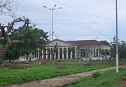
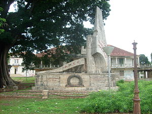 Italian plane crash monument with Governor's palace | |
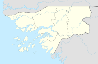
| Coordinates: 11°35′N 15°28′W / 11.583°N 15.467°W | |
| Country | |
| Region | Bolama Region |
| Area | |
• Total | 65 km2 (25 sq mi) |
| Elevation | 0 m (0 ft) |
| Population (2009)[1] | |
• Total | 6,024 |
| • Density | 93/km2 (240/sq mi) |
Bolama is the main town of Bolama Island and the capital of the Bolama Region. It has a population of 4,819 (2009 census).[1]
It is almost surrounded by mangrove swamps and is known for its cashew nuts. Although often visited by local people, the island was apparently uninhabited when .
History

Bolama was first settled in 1792 by British colonists. Following a series of failures, they abandoned Bolama in 1794, another colonisation attempt in 1814 also being quickly ended. 1879, Bolama became the first capital of Portuguese Guinea and remained so until its transfer to Bissau in 1941. Bissau had been founded in 1687 by Portugal as a fortified port and trading center. This transfer was needed due to the shortage of fresh water in Bolama. Bolama later became a seaplane stop, and a seaplane crash in 1931 is commemorated by a statue in the town.
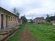
The abandoned houses of the old capital provide a shelter for many thousands of enormous fruit eating bats. Every evening, these bats flock to the mainland, darkening the skies.
A fruit processing plant was built on Bolama shortly after independence of Guinea Bissau, with Dutch foreign aid. This plant produced canned juice and jelly of cashew fruit. However, it could not expand and had to shut down its operations, due to the shortage of fresh water on the island.
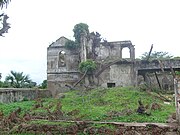
Attractions of Bolama are its abandoned ruins, particularly the Bolama Governor's Palace.
Twin towns – sister cities
Bolama is twinned with:
Gallery
Further reading
- The history of the English colonisation attempt in 1792 is chronicled in the first six chapters of the 2013 book, "The Ship of Death: The Voyage that Changed the Atlantic World" by (professor of history) Billy G. Smith.[3]
References
- ^ a b População por região, sector e localidades por sexo censo 2009, Instituto Nacional de Estatística Guiné-Bissau
- ^ "Geminações de Cidades e Vilas". Associação Nacional de Municípios Portugueses (in Portuguese). Retrieved 2013-07-20.
- ^ The Ship of Death Yale University Press, 2013; accessed 26 September 2014.
External links
- Abolition Gone Wrong - article about the failed 1792 English settlement of Bolama
- Bolama Region
- Populated places in Guinea-Bissau
- Populated places established in 1792
- 1792 establishments in the British Empire
- 1794 disestablishments in the British Empire
- 1830 establishments in Portuguese Guinea
- 1860 disestablishments in Portuguese Guinea
- 1860 establishments in the British Empire
- 1870 disestablishments in the British Empire
- 1870 establishments in Portuguese Guinea

