Ortenburg, Bavaria: Difference between revisions
→History: add |
|||
| Line 44: | Line 44: | ||
==Notable residents== |
==Notable residents== |
||
* [[Heinrich Deubel]] (1890–1962), Nazi SS concentration camp commandant |
* [[Heinrich Deubel]] (1890–1962), Nazi SS [[Dachau concentration camp]] commandant |
||
==References== |
==References== |
||
Revision as of 19:11, 5 July 2020
You can help expand this article with text translated from the corresponding article in German. (March 2009) Click [show] for important translation instructions.
|
Ortenburg, Bavaria | |
|---|---|
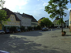
 Ortenburg town centre | |
Location of Ortenburg, Bavaria within Passau district  | |
| Coordinates: 48°32′N 13°13′E / 48.533°N 13.217°E | |
| Country | Germany |
| State | Bavaria |
| Admin. region | Niederbayern |
| District | Passau |
| Government | |
| • Mayor | Stefan Lang (CSU) |
| Area | |
• Total | 60.73 km2 (23.45 sq mi) |
| Elevation | 358 m (1,175 ft) |
| Population (2023-12-31)[1] | |
• Total | 7,525 |
| • Density | 120/km2 (320/sq mi) |
| Time zone | UTC+01:00 (CET) |
| • Summer (DST) | UTC+02:00 (CEST) |
| Postal codes | 94496 |
| Dialling codes | 08542 |
| Vehicle registration | PA |
| Website | www.ortenburg.de |
Ortenburg is a municipality and old market town in the district of Passau in Bavaria in Germany.
Geography
Geographical location
Ortenburg is situated in the forested area south of the Danube and north of the Rott. It is one of the main centres of population in the Lower Bavarian Upland. The majority of the municipality is located in the Wolfach Valley and the Wolfach itself runs directly through Ortenburg.
The market town lies 20 km west of Passau, 10 km south of Vilshofen an der Donau, 12 km northwest of Bad Griesbach and 20 km north of Pocking.
Neighbouring municipalities
The closest municipalities are Haarbach, Beutelsbach, Vilshofen an der Donau, Fürstenzell, and Bad Griesbach im Rottal. The cities of Passau and Pocking are somewhat farther away.
Administrative division
The municipality of Ortenburg includes 112 districts.[2]
History

Set in the Wolfach River valley, Ortenburg can look back over a 900-year history. In about 1120 it was established by the Counts of Ortenburg. At the same time the upwardly mobile von Kamm family appeared on the scene. However, during the thirteenth century the von Kamms relocated to Hals (now a quarter of Passau). The Ortenburg counts, whose own origins lay with the Spanheimer dynasty, were keen to establish their own separate dynastic centre and such the Imperial County of Ortenburg kept its Imperial immediacy until 1806.
The Ortenburgs were among the most powerful of the Bavarian nobility, competing in terms of power and position with the Wittelsbach dynasty. During the height of their power, during the twelfth and thirteenth centuries, the Ortenburgs held lands from as far south as the Brixen valley, that extended also far into the Upper Palatinate.
Notable residents
- Heinrich Deubel (1890–1962), Nazi SS Dachau concentration camp commandant
References
- ^ Genesis Online-Datenbank des Bayerischen Landesamtes für Statistik Tabelle 12411-003r Fortschreibung des Bevölkerungsstandes: Gemeinden, Stichtag (Einwohnerzahlen auf Grundlage des Zensus 2011).
- ^ "Bayerische Landesbibliothek Online (BLO)". www.bayerische-landesbibliothek-online.de (in German). Retrieved 2017-03-09.


