Vauréal: Difference between revisions
Appearance
Content deleted Content added
m Task 15: language icon template(s) replaced (4×); |
m rm unused infobox parameters, removed: |region , |department , *[http://www.insee.fr/en/home/home_page.asp INSEE] |
||
| Line 9: | Line 9: | ||
|adjustable map = Vaureal_map.png |
|adjustable map = Vaureal_map.png |
||
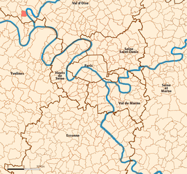
|map caption = Location (in red) within Paris inner and outer suburbs |
|map caption = Location (in red) within Paris inner and outer suburbs |
||
|region = Île-de-France |
|||
|department = Val-d'Oise |
|||
|arrondissement = Pontoise |
|arrondissement = Pontoise |
||
|canton = Vauréal |
|canton = Vauréal |
||
| Line 29: | Line 27: | ||
French [[chocolatier|chocolate maker]] [[Henri Menier]] (1853–1913) had a [[château]] in Vauréal and named the 70-metre-high Vauréal Falls on [[Anticosti Island]] in [[Quebec province]] of [[Canada]] after the town. |
French [[chocolatier|chocolate maker]] [[Henri Menier]] (1853–1913) had a [[château]] in Vauréal and named the 70-metre-high Vauréal Falls on [[Anticosti Island]] in [[Quebec province]] of [[Canada]] after the town. |
||
==Transportation== |
==Transportation== |
||
Vauréal is served by no station of the Paris Métro, RER, or suburban rail network. The closest station to Vauréal is [[Cergy – Le Haut (SNCF)|Cergy – Le Haut]] station on Paris [[RER A|RER line A]] and on the [[Transilien Paris – Saint-Lazare]] suburban rail line. This station is located in the neighboring commune of [[Cergy]], {{convert|2.2|km|mi|abbr=on}} from the town center of Vauréal. |
Vauréal is served by no station of the Paris Métro, RER, or suburban rail network. The closest station to Vauréal is [[Cergy – Le Haut (SNCF)|Cergy – Le Haut]] station on Paris [[RER A|RER line A]] and on the [[Transilien Paris – Saint-Lazare]] suburban rail line. This station is located in the neighboring commune of [[Cergy]], {{convert|2.2|km|mi|abbr=on}} from the town center of Vauréal. |
||
| Line 42: | Line 41: | ||
==References== |
==References== |
||
*[http://www.insee.fr/en/home/home_page.asp INSEE] |
|||
| ⚫ | |||
{{reflist}} |
{{reflist}} |
||
| Line 51: | Line 48: | ||
*[http://www.culture.gouv.fr/public/mistral/merimee_fr?ACTION=CHERCHER&FIELD_98=INSEE&VALUE_98=95637 Mérimée database - Cultural heritage] {{in lang|fr}} |
*[http://www.culture.gouv.fr/public/mistral/merimee_fr?ACTION=CHERCHER&FIELD_98=INSEE&VALUE_98=95637 Mérimée database - Cultural heritage] {{in lang|fr}} |
||
*[http://www.iaurif.org/en/gis/fichescom/mos99/ficmos/mos95637.html Land use (IAURIF)] {{in lang|en}} |
*[http://www.iaurif.org/en/gis/fichescom/mos99/ficmos/mos95637.html Land use (IAURIF)] {{in lang|en}} |
||
| ⚫ | |||
{{Cergy-Pontoise}} |
{{Cergy-Pontoise}} |
||
{{Paris Metropolitan Area}} |
{{Paris Metropolitan Area}} |
||
| Line 56: | Line 55: | ||
{{Authority control}} |
{{Authority control}} |
||
{{DEFAULTSORT:Vaureal}} |
{{DEFAULTSORT:Vaureal}} |
||
[[Category:Communes of Val-d'Oise]] |
[[Category:Communes of Val-d'Oise]] |
||
[[Category:Cergy-Pontoise]] |
[[Category:Cergy-Pontoise]] |
||
{{ValOise-geo-stub}} |
{{ValOise-geo-stub}} |
||
Revision as of 18:09, 9 July 2020
Vauréal | |
|---|---|
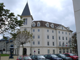
 Town hall | |
 Location (in red) within Paris inner and outer suburbs | |
| Coordinates: 49°02′07″N 2°01′58″E / 49.0353°N 2.0328°E | |
| Country | France |
| Region | Île-de-France |
| Department | Val-d'Oise |
| Arrondissement | Pontoise |
| Canton | Vauréal |
| Intercommunality | Cergy-Pontoise |
| Government | |
| • Mayor (2001–2008) | Bernard Morin |
Area 1 | 3.46 km2 (1.34 sq mi) |
| Population (2022)[1] | 16,079 |
| • Density | 4,600/km2 (12,000/sq mi) |
| Time zone | UTC+01:00 (CET) |
| • Summer (DST) | UTC+02:00 (CEST) |
| INSEE/Postal code | 95637 /95490 |
| Elevation | 22–122 m (72–400 ft) |
| 1 French Land Register data, which excludes lakes, ponds, glaciers > 1 km2 (0.386 sq mi or 247 acres) and river estuaries. | |
Vauréal is a commune in the northwestern suburbs of Paris, France. It is located 30.6 km (19.0 mi) from the center of Paris, in the "new town" of Cergy-Pontoise, created in the 1960s.
French chocolate maker Henri Menier (1853–1913) had a château in Vauréal and named the 70-metre-high Vauréal Falls on Anticosti Island in Quebec province of Canada after the town.
Transportation
Vauréal is served by no station of the Paris Métro, RER, or suburban rail network. The closest station to Vauréal is Cergy – Le Haut station on Paris RER line A and on the Transilien Paris – Saint-Lazare suburban rail line. This station is located in the neighboring commune of Cergy, 2.2 km (1.4 mi) from the town center of Vauréal.
Education
Schools include:
- Eight primary schools[2]
- Two junior high schools (collèges): La Bussie and Les Toupets[3]
- One senior high school, Lycée Camille Claudel[3]
See also
References
- ^ "Populations de référence 2022" (in French). The National Institute of Statistics and Economic Studies. 19 December 2024.
- ^ "Les établissements scolaires à Vauréal." Vauréal. Retrieved on September 6, 2016.
- ^ a b "Les établissements secondaires." Vauréal. Retrieved on September 6, 2016.
External links
Wikimedia Commons has media related to Vauréal.
- Official website (in French)
- Mérimée database - Cultural heritage (in French)
- Land use (IAURIF) (in English)
- Association of Mayors of the Val d’Oise (in French)


