Pundibari: Difference between revisions
Appearance
Content deleted Content added
Chandan Guha (talk | contribs) →References: Three columns |
Chandan Guha (talk | contribs) →Geography: OSM Location map placed |
||
| Line 58: | Line 58: | ||
==Geography== |
==Geography== |
||
{{OSM Location map |
|||
| width=320| height=370| zoom=11 |
|||
| coord={{coord|26|20|30|N|89|27|30|E}}| float=left|caption='''Places in the Cooch Behar Sadar subdivision in Cooch Behar district'''<br/>CT: census town, M: municipal town, R: rural/ urban centre, H: historical/ religious centre<br/>Owing to space constraints in the small map, the actual locations in a larger map may vary slightly |
|||
|mark-coord1={{coord|26|20|37|N|89|28|26|E}}| label-pos1=left|label1= Baisguri | numbered1=CT| mark-title1= [[Baisguri]] (CT)|label-color1= #800000 |label-size1=11| mark-size1=12|shape1=l-circle|shape-color1= #A40000 |shape-outline1=white|label-offset-x1=2 |
|||
|mark-coord2={{coord|26|23|30|N|89|29|45|E}}| label-pos2=right|label2=Baneswar| numbered2=CT| mark-title2= [[Baneswar]] (CT) |
|||
|mark-coord3={{coord|26|20|10|N|89|28|44|E}}| label-pos3=right|label3=Chakchaka| numbered3=CT| mark-title3= [[Chakchaka]] (CT) |
|||
|mark-coord4={{coord|26|16|50|N|89|28|18|E}}| label-pos4=left|label4=Dhaliabari| numbered4=CT| mark-title4= [[Dhaliabari]] (CT) |
|||
|mark-coord5={{coord|26|18|49|N|89|27|50|E}}| label-pos5=left|label5=Guriahati| numbered5=CT| mark-title5= [[Guriahati]] (CT) |
|||
|mark-coord6={{coord|26|21|36|N|89|27|36|E}}| label-pos6=right|label6=Khagrabari| numbered6=CT| mark-title6= [[Khagrabari]] (CT) |
|||
|mark-coord7={{coord|26|18|55|N|89|28|15|E}}| label-pos7=right|label7=Kharimala Khagrabari| numbered7=CT| mark-title7= [[Kharimala Khagrabari]] (CT) |
|||
|mark-coord8={{coord|26|20|0|N|89|25|55|E}}| label-pos8=left|label8=Takagachh| numbered8=CT| mark-title8= [[Takagachh]] (CT) |
|||
|mark-coord9={{coord|26|19|40|N|89|27|3|E}}| label-pos9=right|label9=Cooch Behar| numbered9=M| mark-title9= [[Cooch Behar]] (M) | shape-color9=#800000 |
|||
|mark-coord10={{coord|26|14|37|N|89|29|10|E}}| label-pos10=right|label10=Dewanhat| numbered10=R| mark-title10= [[Dewanhat]] (R) | shape-color10= #C42222 |
|||
|mark-coord11={{coord|26|17|8|N|89|28|12|E}}| label-pos11=right|label11=Ghughumari| numbered11=R| mark-title11= [[Ghughumari]] (R)| shape-color11= #C42222 |
|||
|mark-coord12={{coord|26|26|15|N|89|22|30|E}}| label-pos12=right|label12=Kalarayerkuthi| numbered12=R| mark-title12= [[Kalarayerkuthi]] (R)| shape-color12= #C42222 |
|||
|mark-coord13={{coord|26|24|32|N|89|22|56|E}}| label-pos13=right|label13=Pundibari| numbered13=R| mark-title13= [[Pundibari]] (R) | shape-color13= #C42222 |
|||
|mark-coord14={{coord|26|17|40|N|89|27|20|E}}| label-pos14=left|label14=Gudam Maharaniganj| numbered14=H| mark-title14= [[Gudam Maharaniganj]] (H) |shape-color14=#AA6666 |
|||
|mark-coord15={{coord|26|19|37|N|89|26|18|E}}| label-pos15=left|label15=Cooch Behar Palace| numbered15=H| mark-title15= [[Cooch Behar Palace]] (H) |shape-color15=#AA6666 |
|||
|mark-coord23={{coord|26|18|0|N|89|29|0|E}}|label23= Mara| label-color23 = #77A1CB| label-angle23=-24| label-pos23=top| label-size23=10| mark-size23=0| mark-title23=none |
|||
|mark-coord24={{coord|26|17|40|N|89|30|30|E}}|label24= Torsha River| label-color24 = #77A1CB| label-angle24=34| label-pos24=top| label-size24=10| mark-size24=0| mark-title24=none}} |
|||
===Location=== |
|||
Pundibari is located at {{coord|26.408890|N|89.382388|E|}}.<ref>{{cite web |
Pundibari is located at {{coord|26.408890|N|89.382388|E|}}.<ref>{{cite web |
||
|url = https://goo.gl/maps/7g5PWZfq1Sr |
|url = https://goo.gl/maps/7g5PWZfq1Sr |
||
| Line 64: | Line 86: | ||
|accessdate = 11 February 2018 |
|accessdate = 11 February 2018 |
||
}}</ref> It is the headquarters of Cooch Behar–II Community Development Block under [[Cooch Behar Sadar subdivision]] of the district.<ref name=distProfile2>{{cite web | url = http://coochbehar.gov.in/Htmfiles/dist_profile.html | title = Cooch Behar District profile | publisher = Official website of Cooch Behar district | accessdate = 25 December 2008}}</ref> |
}}</ref> It is the headquarters of Cooch Behar–II Community Development Block under [[Cooch Behar Sadar subdivision]] of the district.<ref name=distProfile2>{{cite web | url = http://coochbehar.gov.in/Htmfiles/dist_profile.html | title = Cooch Behar District profile | publisher = Official website of Cooch Behar district | accessdate = 25 December 2008}}</ref> |
||
==Civic administration== |
==Civic administration== |
||
Revision as of 23:50, 5 August 2020
Pundibari | |
|---|---|
Village | |
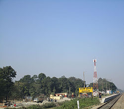
 Pundibari Station Nameplate | |
| Coordinates: 26°24′32″N 89°22′57″E / 26.408888°N 89.382372°E | |
| Country | |
| State | West Bengal |
| District | Cooch Behar |
| Languages | |
| • Official | Bengali[1][2] |
| • Additional official | English[1] |
| Time zone | UTC+5:30 (IST) |
| PIN | 736165 |
| Vehicle registration | WB |
| Nearest city | coochbehar |
| Website | coochbehar |
Pundibari is a village in the Cooch Behar II CD block in the Cooch Behar Sadar subdivision of the Cooch Behar district of West Bengal, India.
Geography

5km
3miles
3miles
Torsha River
Mara
Cooch Behar Palace
H
Gudam Maharaniganj
H
Pundibari
R
Kalarayerkuthi
R
Ghughumari
R
Dewanhat
R
Cooch Behar
M
Takagachh
CT
Kharimala Khagrabari
CT
Khagrabari
CT
Guriahati
CT
Dhaliabari
CT
Chakchaka
CT
Baneswar
CT
Baisguri
CT
Places in the Cooch Behar Sadar subdivision in Cooch Behar district
CT: census town, M: municipal town, R: rural/ urban centre, H: historical/ religious centre
Owing to space constraints in the small map, the actual locations in a larger map may vary slightly
CT: census town, M: municipal town, R: rural/ urban centre, H: historical/ religious centre
Owing to space constraints in the small map, the actual locations in a larger map may vary slightly
Location
Pundibari is located at 26°24′32″N 89°22′57″E / 26.408890°N 89.382388°E.[3] It is the headquarters of Cooch Behar–II Community Development Block under Cooch Behar Sadar subdivision of the district.[4]
Civic administration
Police station
There is a police station at Pundibari. [5][6]
Education
Uttar Banga Krishi Vishwavidyalaya is situated here.
Healthcare
Pundibari Rural Hospital, with 30 beds at Pundibari, is the major government medical facility in the Cooch Behar II CD block. [7]
References
- ^ a b "Fact and Figures". www.wb.gov.in. Retrieved 12 March 2019.
- ^ "52nd REPORT OF THE COMMISSIONER FOR LINGUISTIC MINORITIES IN INDIA" (PDF). nclm.nic.in. Ministry of Minority Affairs. p. 85. Archived from the original (PDF) on 25 May 2017. Retrieved 12 March 2019.
- ^ "Google maps location of Pundibari". Google maps. Retrieved 11 February 2018.
- ^ "Cooch Behar District profile". Official website of Cooch Behar district. Retrieved 25 December 2008.
- ^ "Police Stations". Cooch Behar Police. Retrieved 26 July 2020.
- ^ "Police Stations under Cooch Behar district". Cooch Behar Police. Retrieved 26 July 2020.
- ^ "Health & Family Welfare Department" (PDF). Health Statistics – Rural Hospitals. Government of West Bengal. Retrieved 29 July 2020.


