Nông Hạ: Difference between revisions
Appearance
Content deleted Content added
m Moving from Category:Populated places in Bac Kan Province to Category:Populated places in Bắc Kạn Province using Cat-a-lot |
TerraCyprus (talk | contribs) |
||
| Line 1: | Line 1: | ||
{{Infobox |
{{Infobox settlement |
||
<!--See the Table at Infobox Settlement for all fields and descriptions of usage--> |
|||
<!-- Basic info ----------------> |
<!-- Basic info ----------------> |
||
|name = Nông Hạ |
|name = Nông Hạ |
||
| Line 64: | Line 63: | ||
|population_density_blank1_sq_mi = |
|population_density_blank1_sq_mi = |
||
<!-- General information ---------------> |
<!-- General information ---------------> |
||
|timezone = |
|timezone = |
||
|utc_offset = + |
|utc_offset = +07:00 |
||
|timezone_DST = |
|timezone_DST = |
||
|utc_offset_DST = |
|utc_offset_DST = |
||
| Line 92: | Line 91: | ||
[[Category:Populated places in Bắc Kạn Province]] |
[[Category:Populated places in Bắc Kạn Province]] |
||
[[Category:Communes of Bắc Kạn Province]] |
[[Category:Communes of Bắc Kạn Province]] |
||
{{BacKan-geo-stub}} |
{{BacKan-geo-stub}} |
||
Revision as of 22:59, 27 October 2020
Nông Hạ | |
|---|---|
Commune and village | |
 | |
| Country | |
| Province | Bắc Kạn Province |
| District | Chợ Mới District |
| Time zone | UTC+07:00 |
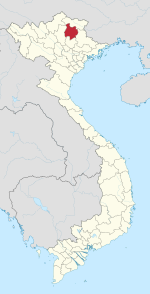
Nông Hạ is a commune (xã) and village in Chợ Mới District, Bắc Kạn Province, in Vietnam.
21°57′N 105°48′E / 21.950°N 105.800°E

