Trier-Land: Difference between revisions
Appearance
Content deleted Content added
No edit summary |
m robot Adding: nl:Verbandsgemeinde Trier-Land |
||
| Line 34: | Line 34: | ||
The village '''Igel''' is known for the Column of Igel, a [[UNESCO]] [[World Heritage Site]]. The Column of Igel is a 23 m high [[Ancient Rome|Roman]] decorated [[tomb]]. |
The village '''Igel''' is known for the Column of Igel, a [[UNESCO]] [[World Heritage Site]]. The Column of Igel is a 23 m high [[Ancient Rome|Roman]] decorated [[tomb]]. |
||
| ⚫ | |||
{{RhinelandPalatinate-geo-stub}} |
{{RhinelandPalatinate-geo-stub}} |
||
[[Category:Verbandsgemeinde in Rhineland-Palatinate]] |
[[Category:Verbandsgemeinde in Rhineland-Palatinate]] |
||
| ⚫ | |||
[[nl:Verbandsgemeinde Trier-Land]] |
|||
Revision as of 06:32, 5 January 2007
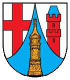
| Arms | Map |
|---|---|

|

|
| Country: | Germany |
| State: | Rhineland-Palatinate |
| District: | Trier-Saarburg |
| Verbandsgemeinde: | Trier-Land |
Trier-Land is a Verbandsgemeinde ("collective municipality") in the Trier-Saarburg district, in Rhineland-Palatinate, Germany. It is situated on the border with Luxembourg, north and west of Trier. The seat of the municipality is in Trier, itself not part of the municipality.
The Verbandsgemeinde Trier-Land consists of the following Ortsgemeinden ("local municipalities"):
- Aach
- Franzenheim
- Hockweiler
- Igel
- Kordel
- Langsur
- Newel
- Ralingen
- Trierweiler
- Welschbillig
- Zemmer
The village Igel is known for the Column of Igel, a UNESCO World Heritage Site. The Column of Igel is a 23 m high Roman decorated tomb.
