Cantoria: Difference between revisions
Appearance
Content deleted Content added
m Removing from Category:Populated places in the Province of Almería in subcat using Cat-a-lot |
+image skyline |
||
| Line 3: | Line 3: | ||
|nickname = |
|nickname = |
||
|motto = |
|motto = |
||
|image_skyline = |
|image_skyline = Cantoria01.png |
||
|imagesize = |
|imagesize = |
||
|image_caption = |
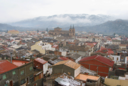
|image_caption = View of Cantoria |
||
|image_flag = |
|image_flag = |
||
|image_seal = Escudo de Cantoria.svg |
|image_seal = Escudo de Cantoria.svg |
||
Revision as of 21:42, 28 October 2020
Cantoria, Spain | |
|---|---|
 View of Cantoria | |
 | |
| Coordinates: 37°21′N 2°11′W / 37.350°N 2.183°W | |
| Country | Spain |
| Province | Almería |
| Government | |
| • Mayor | Pedro María Llamas García (PP) |
| Area | |
• Total | 79 km2 (31 sq mi) |
| Elevation | 382 m (1,253 ft) |
| Population (2018)[1] | |
• Total | 3,228 |
| • Density | 41/km2 (110/sq mi) |
| Time zone | UTC+1 (CET) |
| • Summer (DST) | UTC+2 (CEST) |

Cantoria is a municipality of Almería province, in the autonomous community of Andalusia, Spain.
Demographics
| Year | Pop. | ±% |
|---|---|---|
| 1999 | 3,206 | — |
| 2000 | 3,147 | −1.8% |
| 2001 | 3,147 | +0.0% |
| 2002 | 3,223 | +2.4% |
| 2003 | 3,230 | +0.2% |
| 2004 | 3,382 | +4.7% |
| 2005 | 3,565 | +5.4% |
| 2017 | 3,251 | −8.8% |
| Source: INE (Spain) | ||
References
- ^ Municipal Register of Spain 2018. National Statistics Institute.
External links
- (in Spanish) Cantoria - Sistema de Información Multiterritorial de Andalucía
- (in Spanish) Cantoria - Diputación Provincial de Almería
- (in English) Cantoria Information - General Information about Cantoria

