Ibatiba: Difference between revisions
Appearance
Content deleted Content added
No edit summary |
added info |
||
| Line 1: | Line 1: | ||
{{Infobox settlement |
{{Infobox settlement |
||
| official_name = Ibatiba |
| official_name = Ibatiba |
||
| native_name = |
| native_name = |
||
| settlement_type = [[Municipalities of Brazil|Municipality]] |
| settlement_type = [[Municipalities of Brazil|Municipality]] |
||
| image_shield = |
| image_shield = |
||
| image_flag = |
| image_flag = |
||
| image_skyline = |
| image_skyline = Vista parcial de Ibatiba ES a partir da BR-262.JPG |
||
| image_caption = |
| image_caption = |
||
| image_map = |
| image_map = EspiritoSanto Municip Ibatiba.svg |
||
| map_caption = Location in Espírito Santo state |
| map_caption = Location in Espírito Santo state |
||
| pushpin_map = Brazil |
| pushpin_map = Brazil |
||
| pushpin_map_caption = Location in Brazil |
| pushpin_map_caption = Location in Brazil |
||
| coordinates = {{coord|20|14|11|s|41|30|33|W|region:BR|display=inline,title}} |
| coordinates = {{coord|20|14|11|s|41|30|33|W|region:BR|display=inline,title}} |
||
| subdivision_type = [[List of sovereign states|Country]] |
| subdivision_type = [[List of sovereign states|Country]] |
||
| subdivision_name = Brazil |
| subdivision_name = Brazil |
||
| subdivision_type1 = [[Regions of Brazil|Region]] |
| subdivision_type1 = [[Regions of Brazil|Region]] |
||
| subdivision_name1 = [[Southeast Region, Brazil|Southeast]] |
| subdivision_name1 = [[Southeast Region, Brazil|Southeast]] |
||
| subdivision_type2 = [[States of Brazil|State]] |
| subdivision_type2 = [[States of Brazil|State]] |
||
| subdivision_name2 = [[Espírito Santo]] |
| subdivision_name2 = [[Espírito Santo]] |
||
| subdivision_type3 = [[Mesoregions of Brazil|Mesoregion]] |
| subdivision_type3 = [[Mesoregions of Brazil|Mesoregion]] |
||
| subdivision_name3 = |
| subdivision_name3 = |
||
| subdivision_type4 = [[Microregion (Brazil)|Microregion]] |
| subdivision_type4 = [[Microregion (Brazil)|Microregion]] |
||
| subdivision_name4 = |
| subdivision_name4 = |
||
| subdivision_type5 = [[Metropolitan area#Brazil|Metrop. region]] |
| subdivision_type5 = [[Metropolitan area#Brazil|Metrop. region]] |
||
| subdivision_name5 = |
| subdivision_name5 = |
||
| established_title = |
| established_title = Established |
||
| established_date = |
| established_date = 7 November 1981 |
||
| leader_party = |
| leader_party = |
||
| leader_title = [[Mayor]] |
| leader_title = [[Mayor]] |
||
| leader_name = |
| leader_name = |
||
| elevation_m = |
| elevation_m = |
||
| area_footnotes = |
| area_footnotes = |
||
| area_total_km2 = 241 |
| area_total_km2 = 241 |
||
| area_metro_km2 = |
| area_metro_km2 = |
||
| population_footnotes = |
| population_footnotes = |
||
| population_total = 25,244 |
| population_total = 25,244 |
||
| population_as_of = 2015 |
| population_as_of = 2015 |
||
| population_metro = |
| population_metro = |
||
| population_density_km2 = auto |
| population_density_km2 = auto |
||
| population_demonym = |
| population_demonym = |
||
| blank_name_sec1 = [[Human Development Index|HDI]] |
| blank_name_sec1 = [[Human Development Index|HDI]] |
||
| blank_info_sec1 = |
| blank_info_sec1 = |
||
| timezone1 = [[Time in Brazil|BRT]] |
| timezone1 = [[Time in Brazil|BRT]] |
||
| utc_offset1 = -03:00 |
| utc_offset1 = -03:00 |
||
| timezone1_DST = [[Daylight saving time in Brazil|BRST]] |
| timezone1_DST = [[Daylight saving time in Brazil|BRST]] |
||
| utc_offset1_DST = -02:00 |
| utc_offset1_DST = -02:00 |
||
| postal_code_type = [[List of postal codes in Brazil|Postal code]] |
| postal_code_type = [[List of postal codes in Brazil|Postal code]] |
||
| postal_code = |
| postal_code = |
||
| area_code_type = [[List of dialling codes in Brazil|Area code]] |
| area_code_type = [[List of dialling codes in Brazil|Area code]] |
||
| area_code = |
| area_code = |
||
| website = |
| website = |
||
| name = |
|||
}} |
}} |
||
'''Ibatiba, Espírito Santo''' is a [[municipality]] located in the [[States of Brazil|Brazilian state]] of [[Espírito Santo]]. Its population was 25,244 (2015) and its area is 241 km²<ref>{{Cite web |url=http://cod.ibge.gov.br/4OI|title=Municipality data|accessdate=2016-06-15 |publisher=[[Brazilian Institute of Geography and Statistics]] (IBGE)}}</ref> |
'''Ibatiba, Espírito Santo''' is a [[municipality]] located in the [[States of Brazil|Brazilian state]] of [[Espírito Santo]]. Its population was 25,244 (2015) and its area is 241 km²<ref>{{Cite web |url=http://cod.ibge.gov.br/4OI|title=Municipality data|accessdate=2016-06-15 |publisher=[[Brazilian Institute of Geography and Statistics]] (IBGE)}}</ref> |
||
Revision as of 02:41, 21 November 2020
Ibatiba | |
|---|---|
 | |
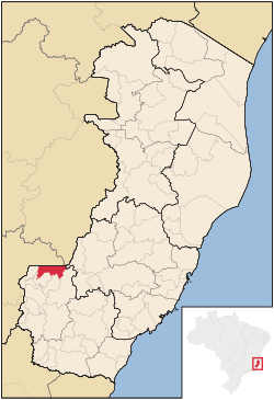
 Location in Espírito Santo state | |
| Coordinates: 20°14′11″S 41°30′33″W / 20.23639°S 41.50917°W | |
| Country | Brazil |
| Region | Southeast |
| State | Espírito Santo |
| Established | 7 November 1981 |
| Area | |
• Total | 241 km2 (93 sq mi) |
| Population (2015) | |
• Total | 25,244 |
| • Density | 100/km2 (270/sq mi) |
| Time zone | UTC-03:00 (BRT) |
| • Summer (DST) | UTC-02:00 (BRST) |
Ibatiba, Espírito Santo is a municipality located in the Brazilian state of Espírito Santo. Its population was 25,244 (2015) and its area is 241 km²[1]
References
- ^ "Municipality data". Brazilian Institute of Geography and Statistics (IBGE). Retrieved 2016-06-15.


