Envira: Difference between revisions
Appearance
Content deleted Content added
m →top: Correct citation errors (deprecated dead-url parameters), and genfixes |
No edit summary |
||
| Line 28: | Line 28: | ||
|population_footnotes = |
|population_footnotes = |
||
|timezone = [[Time in Brazil|BRT]] |
|timezone = [[Time in Brazil|BRT]] |
||
|utc_offset = |
|utc_offset = −5 |
||
|timezone_DST = DST no longer used |
|timezone_DST = DST no longer used |
||
|utc_offset_DST = |
|utc_offset_DST = −5 |
||
|coordinates = {{coord|7|25|58|S|70|1|22|W|region:BR|display=inline,title}} |
|coordinates = {{coord|7|25|58|S|70|1|22|W|region:BR|display=inline,title}} |
||
|elevation_m = |
|elevation_m = |
||
Revision as of 04:54, 30 November 2020
Envira | |
|---|---|
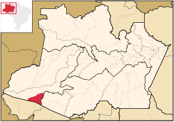
 Location of the municipality inside Amazonas | |
| Coordinates: 7°25′58″S 70°1′22″W / 7.43278°S 70.02278°W | |
| Country | |
| Region | North |
| State | |
| Time zone | UTC−5 (BRT) |
| • Summer (DST) | UTC−5 (DST no longer used) |
Envira is a municipality in the Brazilian state of Amazonas. Its population was 13,548 as of 2005, and its area is 13,369 km2 (5,162 sq mi).[1]
References
- ^ IBGE - "Archived copy". Archived from the original on 2007-01-09. Retrieved 2014-08-03.
{{cite web}}: CS1 maint: archived copy as title (link)


