Sde Yitzhak: Difference between revisions
Appearance
Content deleted Content added
m →top: Task 24: replacement of Template:Lang-he-n following a TFD |
|||
| Line 3: | Line 3: | ||
| image = File:SdeItzhak 6702.jpg |
| image = File:SdeItzhak 6702.jpg |
||
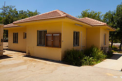
| caption = Village council building |
| caption = Village council building |
||
| hebname = {{Hebrew|שְׂדֵה יִצְחָק}} |
| hebname = {{Script/Hebrew|שְׂדֵה יִצְחָק}} |
||
| foundation = 1952 |
| foundation = 1952 |
||
| founded_by = [[Polish Jews]] |
| founded_by = [[Polish Jews]] |
||
Revision as of 02:28, 7 January 2021
Sde Yitzhak
שְׂדֵה יִצְחָק | |
|---|---|
 Village council building | |
| Coordinates: 32°24′14.04″N 34°59′40.2″E / 32.4039000°N 34.994500°E | |
| Country | Israel |
| District | Haifa |
| Council | Menashe |
| Affiliation | Moshavim Movement |
| Founded | 1952 |
| Founded by | Polish Jews |
| Population (2022)[1] | 730 |
| Website | www.sde-yizhak.com |
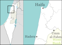
Sde Yitzhak (Template:Lang-he, lit. Field of Yitzhak) is a moshav in northern Israel. Located in the eastern Sharon plain to the south-east of Hadera, it falls under the jurisdiction of Menashe Regional Council. In 2022 it had a population of 730.[1]
History
The village was established in 1952 on the former site of Lahavot Haviva, which had moved to its present location three kilometres east the previous year. The founders were immigrants from Poland.[2] The moshav was named after Yitzhak Sadeh, a founder of the Palmach.[2]

