Domfront en Poiraie: Difference between revisions
Appearance
Content deleted Content added
m Markussep moved page Domfront-en-Poiraie to Domfront en Poiraie: official name has no hyphens |
mNo edit summary |
||
| Line 1: | Line 1: | ||
{{short description|Commune in Orne, France}} |
{{short description|Commune in Orne, France}} |
||
{{Infobox French commune |
{{Infobox French commune |
||
|name = Domfront |
|name = Domfront en Poiraie |
||
|commune status = [[Communes of France|Commune]] |
|commune status = [[Communes of France|Commune]] |
||
|image = Domfront - La mairie.JPG |
|image = Domfront - La mairie.JPG |
||
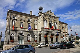
|caption = The town hall of Domfront |
|caption = The town hall of Domfront |
||
|arrondissement = Argentan |
|arrondissement = Argentan |
||
|canton = Domfront |
|canton = Domfront en Poiraie |
||
|INSEE = 61145 |
|INSEE = 61145 |
||
|postal code = 61700 |
|postal code = 61700 |
||
| Line 21: | Line 21: | ||
|population footnotes = {{France metadata Wikidata|population_footnotes}} |
|population footnotes = {{France metadata Wikidata|population_footnotes}} |
||
}} |
}} |
||
'''Domfront |
'''Domfront en Poiraie''' is a [[Communes of France|commune]] in the [[Departments of France|department]] of [[Orne]], northwestern [[France]]. The municipality was established on 1 January 2016 by merger of the former communes of [[Domfront, Orne|Domfront]] (the seat), [[La Haute-Chapelle]] and [[Rouellé]].<ref>[https://www.legifrance.gouv.fr/eli/arrete/2015/12/21/INTB1532157A/jo/texte Arrêté préfectoral] 21 December 2015 {{in lang|fr}}</ref> |
||
== See also == |
== See also == |
||
Revision as of 11:55, 8 January 2021
Domfront en Poiraie | |
|---|---|
 The town hall of Domfront | |
| Coordinates: 48°35′38″N 0°39′00″W / 48.594°N 0.650°W | |
| Country | France |
| Region | Normandy |
| Department | Orne |
| Arrondissement | Argentan |
| Canton | Domfront en Poiraie |
Area 1 | 65.49 km2 (25.29 sq mi) |
| Population (2022)[1] | 4,131 |
| • Density | 63/km2 (160/sq mi) |
| Time zone | UTC+01:00 (CET) |
| • Summer (DST) | UTC+02:00 (CEST) |
| INSEE/Postal code | 61145 /61700 |
| 1 French Land Register data, which excludes lakes, ponds, glaciers > 1 km2 (0.386 sq mi or 247 acres) and river estuaries. | |
Domfront en Poiraie is a commune in the department of Orne, northwestern France. The municipality was established on 1 January 2016 by merger of the former communes of Domfront (the seat), La Haute-Chapelle and Rouellé.[2]
See also
References
Wikimedia Commons has media related to Domfront en Poiraie.
- ^ "Populations de référence 2022" (in French). The National Institute of Statistics and Economic Studies. 19 December 2024.
- ^ Arrêté préfectoral 21 December 2015 (in French)


