Sde Moshe: Difference between revisions
Appearance
Content deleted Content added
No edit summary |
|||
| Line 3: | Line 3: | ||
| image = Sde Moshe Aerial View.jpg |
| image = Sde Moshe Aerial View.jpg |
||
| hebname = {{Script/Hebrew|שְׂדֵה מֹשֶׁה}} |
| hebname = {{Script/Hebrew|שְׂדֵה מֹשֶׁה}} |
||
|arname=سدي موشي |
|||
| meaning = Moshe's Field |
| meaning = Moshe's Field |
||
| founded = 1956 |
| founded = 1956 |
||
Revision as of 15:36, 9 January 2021
Sde Moshe
שְׂדֵה מֹשֶׁה سدي موشي | |
|---|---|
 | |
| Etymology: Moshe's Field | |
| Coordinates: 31°36′38.16″N 34°48′7.91″E / 31.6106000°N 34.8021972°E | |
| Country | Israel |
| District | Southern |
| Council | Lakhish |
| Affiliation | Moshavim Movement |
| Founded | 1956 |
| Population (2022)[1] | 800 |
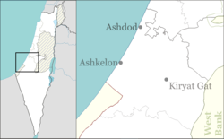
Sde Moshe (Template:Lang-he, lit. Moshe Field) is a moshav in south-central Israel. Located in Hevel Lakhish, about three kilometres east of Kiryat Gat, it falls under the jurisdiction of Lakhish Regional Council. In 2022 it had a population of 800.[1]
History
Sde Moshe was founded in 1956 as part of a movement from the city to the village, on land of the depopulated Palestinian village Iraq al-Manshiyya.[2]
It is named after Baron Maurice de Hirsch, whose Hebrew name was Moshe, and who was one of the founders of the Jewish Colonization Association. It was originally named "Sde Yeshayahu."[citation needed]
References
- ^ a b "Regional Statistics". Israel Central Bureau of Statistics. Retrieved 21 March 2024.
- ^ Khalidi, Walid (1992). All That Remains. Washington D.C.: Institute for Palestine Studies. ISBN 0-88728-224-5. p.108

