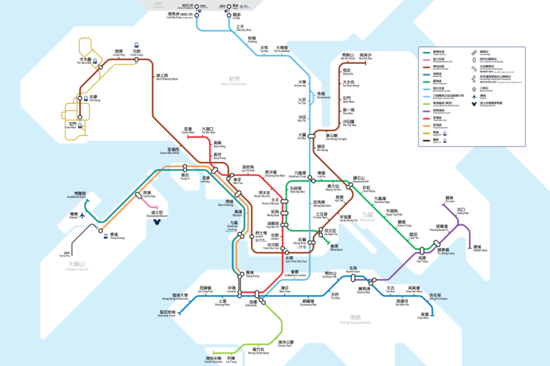
File:FutureMTRNetworkAfterMerger.png
Appearance

Size of this preview: 800 × 533 pixels. Other resolutions: 320 × 213 pixels | 640 × 427 pixels | 1,024 × 683 pixels | 1,280 × 853 pixels | 2,560 × 1,707 pixels | 5,315 × 3,543 pixels.
Original file (5,315 × 3,543 pixels, file size: 1.3 MB, MIME type: image/png)
File history
Click on a date/time to view the file as it appeared at that time.
| Date/Time | Thumbnail | Dimensions | User | Comment | |
|---|---|---|---|---|---|
| 18:06, 12 July 2007 |  | 1,983 × 2,175 (417 KB) | Xavier114fch | New revision with updated information of Shatin-Central Link. | |
| 17:03, 12 April 2007 |  | 1,988 × 2,180 (889 KB) | Xavier114fch | {{Information |Description= Proposed Rail Map after the merger of MTR and KCR |Source= Self-drawn |Date= 10 August 2006 |Author= Xavier Fung |Permission={{cc-by-sa-2.5}}}} | |
| 14:05, 11 August 2006 |  | 1,988 × 2,180 (905 KB) | Xavier114fch | Corrected the character 線 with the Hong Kong character 綫, which appears in MTR system map. | |
| 16:28, 5 August 2006 |  | 1,988 × 2,181 (988 KB) | Xavier114fch | This is the correct one. Why should I upload the wrong one? | |
| 16:26, 5 August 2006 |  | 2,640 × 3,351 (710 KB) | Xavier114fch | Updated version with Causeway Bay North station tag added. | |
| 15:00, 23 July 2006 |  | 1,984 × 2,176 (826 KB) | Xavier114fch | {{Information |Description= Proposed Rail Map after the merger of MTR and KCR |Source= Self-drawn |Date= 23 July 2006 |Author= Xavier114fch |Permission= CC-BY-SA-2.5 }} | |
| 14:56, 23 July 2006 |  | 8,880 × 11,170 (3.84 MB) | Xavier114fch | {{Information |Description= Proposed Rail Map after the merger of MTR and KCR |Source= Self-drawn |Date= 23 July 2006 |Author= Xavier114fch |Permission= }} | |
| 16:52, 20 April 2006 |  | 3,968 × 4,354 (926 KB) | Xavier114fch | ||
| 16:49, 20 April 2006 |  | 3,968 × 4,354 (926 KB) | Xavier114fch | All langs will display the same image. | |
| 20:48, 14 April 2006 |  | 1,983 × 2,175 (391 KB) | Xavier114fch | This is a proposed expanded map for MTR which includes KCR lines after the MTR-KCR merger and all proposed lines in their finished state. |
File usage
The following 3 pages use this file:
Global file usage
The following other wikis use this file:
- Usage on de.wikipedia.org
- Usage on el.wikipedia.org
- Usage on fa.wikipedia.org
- Usage on hak.wikipedia.org
- Usage on he.wikipedia.org
- Usage on id.wikipedia.org
- Usage on ja.wikipedia.org
- Usage on ko.wikipedia.org
- Usage on nl.wikipedia.org
- Usage on ru.wikipedia.org
- Usage on simple.wikipedia.org
- Usage on ta.wikipedia.org
- Usage on uz.wikipedia.org
- Usage on xmf.wikipedia.org
- Usage on zh-min-nan.wikipedia.org
- Usage on zh.wikipedia.org


