Lahore Ring Road
|
Lahore Ring Road لاہور مداری سڑک | |
|---|---|
| Route information | |
| Maintained by Punjab Highway Department | |
| Length | 85 km (53 mi) |
| Existed | 2009–present |
| Location | |
| Country | Pakistan |
| Highway system | |
This article has multiple issues. Please help improve it or discuss these issues on the talk page. (Learn how and when to remove these messages)
|
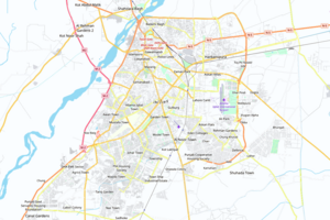
The Lahore Ring Road (لاہور مداری سڑک) is an 85-kilometer-long (53 mi) orbital highway located in Lahore, Pakistan. It links to the M-2 Motorway, the M-11 Motorway, and the N5 National Highway.


Route
The road encircles Lahore. Its route is from Babu Sabu to Saggian Interchange, Lahore, Niazi Chowk. From there it runs to Mehmood Booti, passing through GT road, Canal Bank Road, Harbanspura Interchange, Barki Road, Abdullah Gul Interchange, Allama Iqbal International Airport, Ghazi Road, DHA Phase V & VII, Sui Gas Society, Ferozpur Road, to Hudaira Drain (South) to Halloki, Bahria Town to Niaz Biag.
An emergency lane is present on both sides of the road. It is estimated that 425,000 vehicles pass through daily. All linking roads with Lahore Ring Road were to be improved and widened. As many as 20 interchanges were to be erected.
Features

The project includes the construction of a six-lane divided carriageway, interchanges, RCC bridges, reinforced earth abutments/walls, overhead pedestrian bridges, culverts, sub-ways, underpasses, flyovers and related works.
Length: 85 km
Lanes: 6
Speed limit: minimum speed is 80km/hr, maximum speed is 100km/h for heavy transport vehicles and 120km/h for light transport vehicles
Separation: central raised concrete median and grade-separated junctions
Access: restricted to fast moving vehicles only, including high-performance heavy bikes. The road is fenced on either side. Pedestrians, bicycles, low-performance motorcycles, animal-driven carriages, and other slow-moving vehicles are not permitted.
History
The project was conceived in 1992. The six-lane road (177 kilometres) was estimated to cost Rs 117 billion. The eventual ring road, with six lanes stretching out to 443 km, comes at the cost of Rs 185 billion while the same road with 177 km will cost approximately Rs 1150 billion.[clarification needed] Changes in government caused delays and changes in the project and the total cost estimates shot up due to increased land acquisition, improvement of existing roads used in the project, shifting of utility installations, protecting commercial and residential areas and improvements to junctions.
Explanations for the overrun included delays from lack of professional capabilities, loose checks and balances and the absence of third-party oversight. Contracts were awarded to handpicked contractors without first acquiring the land. The project was the largest development scheme in the history of the metropolis. Usually, land is acquired by LDA[clarification needed] land acquisition collector, and EDO[clarification needed] revenue, but in this project the Board of Revenue was exclusively involved in acquiring the land.
Studies were carried out on the road over this period. The road was designed and redesigned, considering the political and economic interests of the ruling party. In 1991, the Japan International Cooperation Agency proposed a road-loop in the city and the World Bank prepared a feasibility report on a 60 km ring road. In 1995, the Lahore Development Authority presented its scheme. At that time, Daewoo and other foreign companies had signed a memorandum of understanding with the LDA.
In 2003, President Pervez Musharraf directed the Punjab government to implement the project. The project was launched on December 22, 2004 at a ground-breaking ceremony attended by President Musharaf.
The Punjab Communication & Works Department Project Management Unit awarded the “Lahore Ring Road Southern Loop Feasibility Study and Selection of Route” to NESPAK in December 2007. This project was awarded to National Logistics Cell in February 2009, which subcontracted the first phase (Package 4, Saggian Interchange) to Habib Construction Services.\ HCS completed this phase in May 2009. The scope of work included a route alignment study, traffic study, environmental impact assessment, project cost estimates, as well as an economic and financial evaluation. The work on the Southern Loop was to start in 2010, but funding problems delayed matters. The start date was pushed 2011. As of 2010 30% of the work on the first phase of the road, from Niazi Chowk to Bund Road, (43 kilometres) was nearing completion. Work on the Southern Loop was also delayed until 2011 and then until 2016. The Kamahan to Adda segment was inaugurated on 22 December 2017.
The southern Loop hosts housing societies that will be linked, such as DHA, Sui Gas Housing Society, Eden Park (adjacent to Lahore Wildlife Park), State Life Housing Society, Eden Gardens, Valencia, Khayaban-e-Amin, Lake City, AWT Scheme, Fazaia Housing Scheme and Bahria Town.
See also
- Indus Highway
- Karakoram Highway
- Makran Coastal Highway
- National Highways of Pakistan
- Transport in Pakistan
- Transport in Lahore
Notes
References
- http://www.nha.gov.pk
- http://www.apnaplot.pk/blog/southern-loop-ring-road-lahore-impact-on-lahore-property-prices/

