Girgaon
Appearance
This article needs additional citations for verification. (August 2014) |
Girgaon
Girgaum | |
|---|---|
Neighbourhood | |
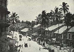
 Girgaon back road, c. 1905 | |
| Coordinates: 18°57′11″N 72°48′47″E / 18.953°N 72.813°E | |
| Country | India |
| State | Maharashtra |
| District | Mumbai City |
| City | Mumbai |
| Government | |
| • Type | Municipal Corporation |
| • Body | Brihanmumbai Municipal Corporation (MCGM) |
| Elevation | 12 m (39 ft) |
| Demonym | Girgaonkar |
| Languages | |
| • Official | Marathi |
| Time zone | UTC+5:30 (IST) |
| PIN | 400004 |
Girgaon, formerly Girgaum, is an area in southern Mumbai in Maharashtra, India.
Etymology
The name "Girgaon" is derived from the Sanskrit words "giri" and "grama". The term "gir" (from "giri") stands for hills, and "gaon" (from "grama") denotes a village. Thus, Girgaon means a village at the foothill of mountains.[1][failed verification]
See also
References
- ^ Society, National Geographic. "National Geographic Society". www.nationalgeographic.org. Retrieved 25 January 2021.
External links
Wikimedia Commons has media related to Girgaum.

