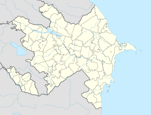
Qarabağlar, Nakhchivan
Qarabağlar
Agarak | |
|---|---|
Municipality | |
| Coordinates: 39°25′31″N 45°11′49″E / 39.42528°N 45.19694°E | |
| Country | |
| Autonomous republic | Nakhchivan |
| District | Kangarli |
| Population | |
• Total | 1,143 |
| Time zone | UTC+4 (AZT) |
Garabaghlar (Azerbaijani: Qarabağlar) or Agarak (Armenian: [Ագարակ] Error: {{Transliteration}}: transliteration text not Latin script (help)) is a village and the most populous municipality in the Kangarli District of Nakhchivan, Azerbaijan. It has a population of 1,143.
History
Founded in II century A.D. as Armenian fortress and village named Agarak in Nakhchavan gavar (district) of Vaspurakan ashkhar (province) of Armenian Kingdom, which later became part of Bagratid Armenia, Kingdom of Vaspurakan and Zakarid Armenia. In 1604 most of population was deported to Persia by Shah Abbas 1 during the Great Surgun. At 1604-1918 period the village had mixture of Armenian and Caucasian Tatar population. During the Armenian-Tatar clashes at 1905-1918 most of Agarak's Armenian population was exterminated by Tatars, rest fled to Ararat Valley and Vayots Dzor. Since the 1921 the village as well as whole Nakhichevan region was finally attached to Azerbaijani SSR by Bolsheviks.
Historical monuments
Up to 1988 ruins of medieval Armenian church named Surb Astvatzatzin (meaning: Holy Virgin) were still available in the village.
Ethimology
Armenian name Agarak means Farm. In all Turkic languages name Karabaglar means Black Gardens.


