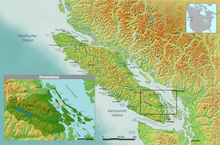
Penelakut Island
This article needs additional citations for verification. (December 2020) |

Penelakut Island | |
|---|---|
 | |
| Coordinates: 48°57′36″N 123°38′42″W / 48.96°N 123.645°W | |
| Country | Canada |
| Government | |
| • MLA | Doug Routley (NDP) |
| Population | |
• Total | 302 |
| Time zone | UTC−8 (PST) |
| • Summer (DST) | UTC−7 (PDT) |
Penelakut Island, formerly known as Kuper Island and renamed in 2010 in honour of the Penelakut First Nation people,[1] is located in the southern Gulf Islands between Vancouver Island and the mainland Pacific coast of British Columbia, Canada. The island has a population of about 300 members of the Penelakut Band. The island has an area of 8.66 square kilometres (3.34 sq mi). There is frequent car and passenger ferry service to Penelakut from Chemainus on Vancouver Island. On its west side sits Telegraph Harbour.[2]
A Mediterranean climate of mild winters and warm, dry summers supports a unique ecosystem and an ideal living environment. The island is in the rain shadow of Vancouver Island, with an annual rainfall of about 850 millimetres (33 in). There is a Roman Catholic Church and a longhouse, but no commercial establishments on the island. From 1890 to 1978, the Catholic Church operated a residential school on the island. There is still much bitterness in the community over the violence and sexual abuse suffered by Aboriginal children who attended the school. One of the priests has been tried and convicted of sexual assault charges dating from his time running the school, and former attendees say the abusive practices were widespread.[3] The present comprehensive school is run by the Penelakut. Because it is an Indian reserve, property is not available for purchase. (There is one private lot dating from the events of 1863).
History
Britain's Royal Navy, surveying the area in 1851, cruised into a group of five islands in the Strait of Georgia, declaring the colonial name of the two largest islands to be Kuper and Thetis, after their Captain Augustus Leopold Kuper R.N. (1809–1885) and his frigate, HMS Thetis, a 36-gun Royal Navy frigate on the Pacific Station between 1851 and 1853.
In 1861 about 300 Bella Bella Indians in 19 large canoes were ordered away from Victoria by Governor Douglas. On their return journey north, they staged a surprise attack at dawn on the Penelahut Natives of Kuper Island, a tribe of about 400 in number. About 225 Penelahuts were murdered in one of the worse massacres recorded.
A Nanaimo chief named Winni-win-chin was visiting Kuper Island. He escaped to Nanaimo and reported the massacre to Mr. A.G. Horne, in charge of the Hudson's Bay Company Post. Mr. Horne dispatched canoe men to Victoria to report the act.
On April 20, 1863, the British gunboat HMS Forward attacked the native village on the then-named Kuper Island. The captain believed that the village harboured individuals of the separate Lamalchi tribe involved in two recent assaults in the Gulf Islands in which three Europeans had been killed in combat. The gunboat fired on the village but, unprepared for a naval landing, withdrew with one casualty after a fierce battle with island warriors. Following the event, the colonial government responded with one of the largest military assaults in British Columbia's history, which took place on the east coast of Vancouver Island and extended throughout the waters and islands of Active Pass, Trincomali Channel and Stuart Channel. Subsequently, having gained control of the region, the government publicly hanged four Indigenous men in Victoria and ultimately established colonial governance in the region, ultimately forming the Province of British Columbia.[citation needed]
Gallery
-
Kuper Island School
-
Ceremonial Dance, Kuper School Gymnasium
-
Ceremonial Canoe Races, 2006, Penelakut
-
Penelakut Longhouse
-
New Friends-Galiano Students visit Penelakut Band School, Penelakut
References
- Daniel Francis (Editor) (1999). Encyclopedia of British Columbia. Harbour Publishing. ISBN 1-55017-200-X.
{{cite book}}:|author=has generic name (help)
- ^ "Penelakut Island - Wikimapia". wikimapia.org. Retrieved February 1, 2018.
- ^ "Telegraph Harbour". BC Geographical Names. Retrieved February 8, 2021.
{{cite web}}: CS1 maint: url-status (link) - ^ "Murder at the Kuper Island Catholic School". canadiangenocide.nativeweb.org. Retrieved February 1, 2018.


