Yalova Province
Appearance
Yalova Province
Yalova ili | |
|---|---|
 Mountains of Termal | |
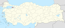
 Location of the province within Turkey | |
| Country | Turkey |
| Seat | Yalova |
| Government | |
| • Vali | Hülya Kaya |
Area | 798 km2 (308 sq mi) |
| Population (2022)[1] | 296,333 |
| • Density | 370/km2 (960/sq mi) |
| Time zone | UTC+3 (TRT) |
| Area code | 0226 |
| Website | www |
Yalova Province (Template:Lang-tr) is a province in northwestern Turkey, on the eastern coast of the Sea of Marmara. Its adjacent provinces are Bursa to the south and Kocaeli to the east. Its area is 798 km2 (making it the smallest province of Turkey),[2] and its population is 296,333 (2022).[1] Prior to 1930, the area around Yalova constituted a district of Kocaeli Province; from 1930 to 1995, it was part of Istanbul Province; in 1995, the area was separated and made into the current Yalova Province.[3][4] The provincial capital is the city of Yalova.
Districts

Yalova Province is divided into six districts:
Notable natives
- Muharrem İnce, Politician
- Mehmet Okur, NBA basketball player
- Şebnem Ferah, Singer
- İzel (İzel Çeliköz), Singer
Gallery
-
An inscription in Karamanli Turkish found on a tombstone in Elmalık, Yalova Province; it says ΤΕΚΕ ΟΓΛΟΥ ΧΑΤΖΙ ΓΙΑΝΙ ΓΙΠΤΙΡΑΝ 1910 'commissioned by Tekeoglou (or son of Teke) Hatzi Yani in 1910'.
-
Ferry port of Armutlu
-
Bozburun Lighthouse, Armutlu.
-
A market in Yalova
References
- ^ a b "Address-based population registration system (ADNKS) results dated 31 December 2022, Favorite Reports" (XLS). TÜİK. Retrieved 19 September 2023.
- ^ "İl ve İlçe Yüz ölçümleri". General Directorate of Mapping. Retrieved 19 September 2023.
- ^ Karar Sayısı: KHK/550, Resmî Gazete, 6 June 1995.
- ^ "İl İdaresi ve Mülki Bölümler Şube Müdürlüğü İstatistikleri - İl ve İlçe Kuruluş Tarihleri" (PDF) (in Turkish). p. 84. Retrieved 25 October 2023.
External links
Wikimedia Commons has media related to Yalova Province.
- (In Turkish) Yalova governor's official website
- (In Turkish) Yalova municipality's official website
- (In English) Yalova weather forecast information


