Sea of Okhotsk Coast
This article or section is in a state of significant expansion or restructuring. You are welcome to assist in its construction by editing it as well. If this article or section has not been edited in several days, please remove this template. If you are the editor who added this template and you are actively editing, please be sure to replace this template with {{in use}} during the active editing session. Click on the link for template parameters to use.
This article was last edited by Altenmann (talk | contribs) 11 months ago. (Update timer) |

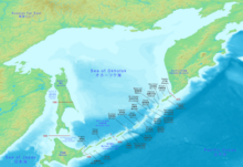
The Sea of Okhotsk Coast (or Okhotsk Coast) is split into natural major parts according to the delineation of the Sea of Okhotsk: its northwestern part, which is part of the mainland of Eastern Siberia (Russian Far East), the west coast of the Kamchatka Peninsula (Russia), the coasts of the Kuril Islands (Russia; some are disputed by Japan), the northeastern coast of Hokkaido (Japan), and the east coast of Sakhalin (Russia).[1][2][3]
Geography
Shoreline
The continental part of the Okhotsk coast has a complicated shape, with many capes gulfs and bays, most significant being the Sakhalin Gulf between Sakhalin and continental Siberia and Shelikhov Gulf, the northernost part of the sea.[1] The (complete) shoreline is broken by a number of straits, most important being Strait of Tartary, La Pérouse Strait, Lindholm Strait, Severnyy Strait, Severo-Vostochnyy Strait, .
Islands
Rivers
Populated places by the shore
History
The first information for Europeans about the Sea of Okhotsk was delivered by the expedition led by Vassili Poyarkov, who came to the Okhotsk coast in 1639 by the mouth of Ulya river. Six years later, in 1645, an expedition led by Ivan Moskvitin travelled by the Amur River down to its mouth.[3] In 1647 an expedition led by Semyon Shelkovnokov (Семен Шелковников, Семейка Шелковник) traveled from Yakutsk to the mouth of Ulya and further to the mouth of Okhota River, where he built a fortified winter quarters (zimovye) in defense from the militant local population, in which place the modern Okhotsk was built.[4]
Economy
References
- ^ a b Физико-географическое описание Охотского моря
- ^ Лоция Охотского моря Книга 1406 вып.1
- ^ a b Pavel Ushakov, Sea of Okhotsk, In: Морской сборник, Issue 1, 1940, pp.69-92
- ^ Семён Андреевич ШЕЛКОВНИКОВ
