Montchaude
Appearance
Montchaude | |
|---|---|
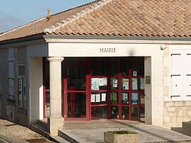
 Town hall | |
| Country | France |
| Region | Nouvelle-Aquitaine |
| Department | Charente |
| Arrondissement | Cognac |
| Canton | Barbezieux-Saint-Hilaire |
| Intercommunality | 3B - Sud-Charente |
| Government | |
| • Mayor (2008–2014) | Pierre Bobe |
Area 1 | 14.18 km2 (5.47 sq mi) |
| Population (2008) | 518 |
| • Density | 37/km2 (95/sq mi) |
| Time zone | UTC+01:00 (CET) |
| • Summer (DST) | UTC+02:00 (CEST) |
| INSEE/Postal code | 16224 /16300 |
| Elevation | 61–147 m (200–482 ft) (avg. 145 m or 476 ft) |
| 1 French Land Register data, which excludes lakes, ponds, glaciers > 1 km2 (0.386 sq mi or 247 acres) and river estuaries. | |
Montchaude is a commune in the Charente department in southwestern France.
Population
| Year | 1793 | 1800 | 1806 | 1821 | 1831 | 1841 | 1846 | 1851 | 1856 | 1861 |
|---|---|---|---|---|---|---|---|---|---|---|
| Population | 1016 | 1022 | 1047 | 1000 | 933 | 909 | 862 | 871 | 850 | 805 |
| Year | 1866 | 1872 | 1876 | 1881 | 1886 | 1891 | 1896 | 1901 | 1906 | 1911 |
|---|---|---|---|---|---|---|---|---|---|---|
| Population | 817 | 766 | 745 | 721 | 673 | 623 | 624 | 602 | 620 | 590 |
| Year | 1921 | 1926 | 1931 | 1936 | 1946 | 1954 | 1962 | 1968 | 1975 | 1982 |
|---|---|---|---|---|---|---|---|---|---|---|
| Population | 519 | 507 | 503 | 478 | 456 | 429 | 420 | 395 | 441 | 454 |
| Year | 1990 | 1999 | 2008 |
|---|---|---|---|
| Population | 463 | 515 | 518 |
See also
References
Wikimedia Commons has media related to Montchaude.

