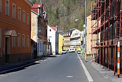
Březová (Karlovy Vary District)
Appearance
Březová (Karlovy Vary District) | |
|---|---|
Municipality and village | |
 | |
 | |
| Country | |
| Region | Karlovy Vary Region |
| District | Karlovy Vary District |
| Area | |
• Total | 0.80 sq mi (2.08 km2) |
| Elevation | 1,380 ft (420 m) |
| Population (2011) | |
• Total | 569 |
| Time zone | UTC+1 (CET) |
| • Summer (DST) | UTC+2 (CEST) |
Březová (Karlovy Vary District) is a village and municipality in Karlovy Vary District in the Karlovy Vary Region of the Czech Republic.
References
Wikimedia Commons has media related to Březová (Karlovy Vary District).
50°11′52″N 12°52′19″E / 50.1978°N 12.8719°E
Wikimedia Commons has media related to Březová (Karlovy Vary District).


