Suchitepéquez Department
Appearance
Suchitepéquez Department
Departmento de Suchitepéquez | |
|---|---|
 Suchitepéquez | |
| Country | |
| Capital | Mazatenango |
| Municipalities | 20 |
| Government | |
| • Type | Departmental |
| Population (Census 2002)[1] | |
| • Religions | Roman Catholicism Evangelicalism Maya |
| Time zone | UTC-6 |
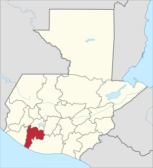
Suchitepéquez (Template:IPA-es) is one of the 22 departments of Guatemala. Its capital is Mazatenango. It is situated in the southwestern region of Guatemala, bordering Quetzaltenango, Sololá, and Chimaltenango to the north, the Pacific Ocean to the south, Escuintla to the east, and Retalhuleu to the west.
Municipalities
- Chicacao
- Cuyotenango
- Mazatenango
- Patulul
- Pueblo Nuevo
- Río Bravo
- Samayac
- San Antonio Suchitepéquez
- San Bernardino
- San Francisco Zapotitlán
- San Gabriel
- San José El Idolo
- San Juan Bautista
- San Lorenzo, Suchitepéquez
- San Miguel Panán
- San Pablo Jocopilas
- Santa Bárbara
- Santo Domingo Suchitepequez
- Santo Tomás La Unión
- Zunilito
References
- ^ "XI Censo Nacional de Poblacion y VI de Habitación (Censo 2002)". INE. 2002.
- "Comunidad Lingüística Ch'orti'". Academia de Lenguas Mayas. 2008. Archived from the original on 2016-03-15.{{cite web}}: Unknown parameter|deadurl=ignored (|url-status=suggested) (help)
Gall, Francis (1976). Diccionario Geográfico de Guatemala. 4 vols. Guatemala: Instituto Geográfico Nacional. {{cite book}}: Cite has empty unknown parameter: |coauthors= (help)
External links
14°32′02″N 91°30′11″W / 14.534°N 91.503°W


